Lupine Publishers| Agriculture Open Access Journal
Abstract
The evolution of remote sensing techniques, the rising availability
of increasingly accurate and reliable technologies and the
widening provision of precise and detailed data constitute the framework
within which more and more specific sectors use remote
sensing. Agriculture is one of the sectors where different applications
of remote sensing can prove their effectiveness as they offer
the possibility of gaining new perspectives, detecting phenomena not
visible from the ground and in replacing man when inspecting
territories dangerous, contaminated or difficult to access is necessary.
Present paper aims to illustrate remote sensing techniques
currently available in olive growing, highlighting their advantages in
terms of optimisation of production processes and natural
resources exploitation, environmental footprint, traceability of final
products and monitoring of yield.
Keywords: Olive growing; Remote sensing; Satellite data; Unmanned aerial vehicle (UAV)
Introduction
Remote sensing is a set of techniques that allows the
exploitation of different way in which natural surfaces interact
with electromagnetic energy from a source to obtain information
about their characteristics. Until a few years ago, data and images
could be acquired just by aircraft equipped with special cameras
whose use had to be designed in detail with considerable expenses
and difficult replicability of acquisition. In recent years, data
acquired by satellites have become available and later continuous
technological evolution has made it possible to perform the same
service at even higher resolution through unmanned aerial vehicle
(UAV), allowing considerable cost savings and, most importantly,
making this technology no longer an exclusive prerogative of
scientific community. At present the choice of instrument depends
essentially on the costs and on the level of detail desired. Using UAV,
increasingly common and executable with different resolutions, still
has a price justified only by large-scale projects; satellite data have
a spatial resolution ranging from 10 m to 30 centimetres, suffer
from interference such as the presence of the atmosphere and
cloud cover but, at lower resolutions, are available free of charge.
At present, the satellite constellations from which data and images
can be drawn are different. Optical satellite images may have spatial
resolutions (i.e., pixel size) of kilometres or even centimetres. In the
case of free data, the spatial resolution is 20 to 30 meters on
the ground and the most common are Landsat, Aster and Sentinel
2 and 3. Multispectral sensors such as Landsat, Spot, Quickbird,
Aster, etc., have low spectral resolutions and therefore have bands
of considerable amplitude; this does not allow good discrimination
of spectral characteristics.
Instead, hyperspectral sensors (Mivis, Aviris, HyMap, etc.)
have a better spectral resolution and allow to obtain a satisfactory
discrimination of some absorption bands. In contrast, hyperspectral
sensors do not have a wide coverage of the Earth’s surface and this
is one of the reasons why multispectral sensors are preferred for
different territorial applications. Remote sensing data with a high
spatial resolution allow a considerable increase in investigation
scale, with performances in terms of accuracy, comparable to those
obtained with traditional aerial photogrammetric techniques.
Increasing spatial resolution makes the detail of the object’s shape
grow, but implies an increment of the parameters needed to describe
classes (Figure 1). Normally, high spatial resolution with current
satellite surveying technologies corresponds to a reduced spectral
resolution, which prevents a detailed description of a surface based
on energy measurements reflected. Moreover, satellite data with
high or very high spatial resolution are hardly free of charge and
for the case studies dealt with, which concern large scale areas,
data with a wider spectral resolution (to the detriment of spatial
resolution) were considered. Different data collection methods
differ in terms of acquisition frequency, processing times and
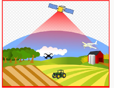
delivery timeliness. Although UAV acquisition can be programmed
as desired while satellite images are acquired at regular intervals,
the latters allow more complex elaborations based on the analysis
of the available historical series. The utilization of UAV is not only
limited to diagnostic context but also to practical applications: in
Italy they have already been successfully tested in the biological
treatment of maize against some kinds of lepidoptera; in Japan,
instead, a large part of spraying with herbicides and fertilizers is
carried out on rice paddies by means of small tanks implanted on
drones which, depending on the parameters measured, dose their
concentrations (Figure 2).
Figure 1: Spectral Signature.
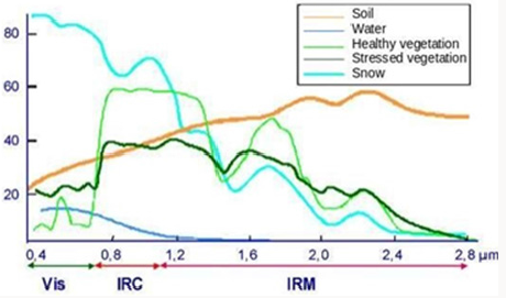
Figure 2: Remote Sensing.
The increasing availability of powerful tools to improve the
efficiency of agronomic practices and the increasing sensitivity to
the environmental footprint of the agricultural sector are having an
important impact in different parts of the world.In the European
context, for example, the Dutch government has budgeted up
to €1.4 million for the purchase of satellite data to improve
sustainability and efficiency of agriculture. These data will include
detailed information on soil characteristics, atmosphere and crop
development. Specialised farms will be able to analyse them to
provide farmers with targeted advice on irrigation, fertilisation and
pesticide spraying activities. Satellite data will be open and starting
from next seasonon dedicated platform (http://satellietdataportaal.
nl), allowing everyone to have free access to the database. Dutch
agricultural and horticultural sector enjoys a strong international
reputation so the government wants to support this leading position
by investing in innovation. Satellite data allow farmers to monitor
crop progress very closely and take corrective action exactly where
it is needed, resulting in greater efficiency and sustainability. Data
purchased by the government will be analysed and processed by
scientific institutes and specialised companies and then converted
into information directly accessible to farmers, for example on the
state of health of the vegetation (http://www.groenmonitor.nl) or
on fertilisation and irrigation (http://www.akkerweb.nl). Smart
methods and technologies will be able to generate significant
savings for farmers in terms of fuel, seeds, artificial fertilisers,
crop protection agents and water. Also FAO has recently developed
software called Collect Earth that exploits the databases of Google
Earth Engine, the portal thanks to which you can access millions of
images taken by U.S. and European satellites, completely free and
open source, in order to bring more and more users to satellite data
to monitor territory, observe land and visualize their evolution.
Moreover it is not by chance that remote sensing techniques
have significantly contributed to the creation of the Information
System and the Territorial Database currently managed by AGEA,
the Agency for Agricultural Disbursements, which since 1982
has started to acquire first aerial data for the establishment of
the olive cultivation register (Reg. n°2276/79). This impressive
and structured data collection is today one of the most important
sources of information not only on the agricultural and forestry
sectors but also on the definition of the evolution of land use and
consequently the identification of land degradation phenomena.
Remote sensing and olive growing
More than 11 million hectares of olives are grown in the
world, spread across the five continents, two hemispheres and 47
countries [1]. At present, olive oil is consumed in over 160 countries
registering a production amounting in more than 2500 thousands
tonnes2. These numbers are an indication of how important olive
sector is for the economy of the 47 producer countries, and how
much an efficiency of the production cycle and a reduction in its
environmental footprint can benefit the entire terrestrial ecosystem.
The application of remote-sensing techniques in olive growing may
to contribute significantly to the increase in olive grove productivity
and to the contextual reduction of the environmental impact of
farming practices. They allow more specific and differentiated
intervention according to the variability within an olive grove, thus
allowing advantages to be obtained in terms of:
a) Monitoring and optimization of fertilization and plant
health protection operations on the basis of site-specific
surveys.
b) The most appropriate choice of irrigation method and
quantity of water to be supplied depending on specific water
demand;
c) Evaluation of the morphological characteristics of
the plants and planning of the most appropriate pruning
operations;
d) The estimation of olive productivity and subsequent oil
yield.
Once the purely cultivation phase is over, monitoring activities
carried out with the support of remote sensing can also be useful
for the traceability of final products (table olives and/or olive oil)
and the consequent possibility of guaranteeing and certifying
origin, cultivation regime (biologic, sod seeding, minimum tillage,
etc.) and other information useful to make the consumer’s choice
as aware as possible.
First high resolution applications have been made by integrating
satellite images and probabilistic techniques for counting olive
trees with the purpose to provide a support in surveying and
inventorying forests and areas covered with other kinds of arboreal
crops and, in particular for olive trees, in assessing estimates of the
production of plantations [2]. With the same purpose of reducing
considerably the effort of manual tree counting and providing a
useful instrument for environmental applications of fruit orchard,
plantation and open forest population monitoring, project called
Arbor Crown Enumerator (ACE) was developed for tree crown
detection from multispectral Very High-resolution (VHR) satellite
imagery [3]. Using a combination of the Red band and Normalized
Difference Vegetation Index (NDVI) thresholding, and the Laplacian
of the Gaussian (LOG) blob detection method, this methodology
is intended to replace the previous OLICOUNT software and to
broaden its scope of application. OLICOUNT, a tool launched by
the European Commission with the specific goal to estimate the
number of olive trees in France, Italy, Spain, Portugal, and Greece,
has automated this counting process to some extent and it has been
an important reference in agricultural policies. It has been used,
for example, to develop an olive tree registration in the framework
of the database accession process to the European Union by the
Turkish Government [4].
Reliable methods for the estimation of crown architecture
is another key issue for the quantitative evaluation of tree crop
adaptation to environment conditions as for an accurate 3D model
of the tree crowns can provide information about critical aspects of
plant growth and development and, therefore, about its suitability
for some specific training systems. This is especially important in
olive breeding programs aimed at developing new cultivars suitable
either to discontinuous (open vase configuration) or continuous
(hedgerow) canopy. Results from studies conducted acquiring data
by means of consumer-grade cameras on board a UAV [5], show
a high agreement between remote sensing estimation and field
measurements of crown parameters. Torres [6] have carried out
several tests to estimate exact volume of canopies through threedimensional
processing of images acquired by drone on different
kinds of olive grove (traditional and very high density). Results
obtained, later compared with on the ground measurements, have
highlighted some differences attributable to the in-field method
of calculating volume. The equation conventionally used, in fact,
considers trees as forms ellipsoidal, leading to inaccurate estimates
due to excessive geometric simplification. This work, in addition to
confirming the potential application of survey techniques by UAV,
also provides an alternative methodology that can fill in application
gaps belonging to traditional procedures.
Some remote sensing applications have been tested on large
olive groves in order to determine the foliar area by indirect
measurements and, on the basis of these, to evaluate presumed
yield and to estimate exact volumes of plant protection products to
be sprayed according to the foliar surface capable of intercepting
the product itself (directly proportional to the foliar surface)
and defining a correct pruning management strategy, in terms of
intensity and rotation. A further interesting application by CNR
and University of Florence’s researchers intended to simulate
the olive-growing productivity through the integration of remote
sensing and in-field data [7]. Multi-step methodology combines
olive NDVI values with meteorological data within a parametric
model that allows the estimation of primary productivity daily
gross weight (GPP). Further elaborations and the use of a specific
biogeochemical model allow them to estimate olive yield expressed
in terms of quintals per hectare. This value, relative to the years
in which the simulation was carried out, was then compared with
data collected in provincial statistics showing the quality of the
method developed and reproducing with satisfactory accuracy the
inter-annual variation in olive yield throughout the whole region.
Current climate change suggests that in many European countries,
as in other parts all over the world, lack of adequate rainfall may be
one of the major factors limiting agricultural production in general.
For this reason, some applications have been developed with the
specific aim of monitoring the water stress of crops and optimizing
the use of water resources. One of these studies was conducted in
Chile [8] and led to the design of a real Geo-Informatics System for
Irrigation Management aimed to increase water productivity (kg/
m3) and to adapt agricultural systems to water scarcity. Water
demand of olive trees as well as biomass production and, therefore,
crop yield are directly related to the ability of plants to absorb and
convert solar radiation.
In this framework, stand all the researches aimed at
establishing two-way relations between the fraction of Intercepted
Photo synthetically Active Radiation (fIPAR) and some kind of
satellite index. Just for example, scientific studies carried out in
Spain [9] investigated on the relationship between fIPAR and the
Normalized Difference Vegetation Index (NDVI) using radiative
transfer modelling methods and field measurements. In the field
of disease detection some remote sensing-based efficient methods
were developed for detecting eventual disease in early stages and
for discriminating among severity levels in order to adequately
calibrate the kind of intervention. Calderon [10], for example,
assessed the potential of using vegetation indices for the early
detection of the soil-borne fungus Verticillium wilt in olive orchards
using indicators based on crown temperature (CWSI), visible ratios
(B, BG, BR), and chlorophyll fluorescence estimates FLD3 to detect
disease in earlier stages and structural multispectral indices such
as Normalized Difference Vegetation Index (NDVI), PRI, chlorophyll
and carotenoid indices for the detection of the presence of moderate
to severe damage [11]. Ultimately it seems appropriate to present
the case of an application conducted by the USDA Forest Service
to detect and to evaluate the spread of Russian olive (Elaeagnus
angustifolia L.) throughout the Fishlake National Forest [12]. This
plant, a thorny shrub or tree, was intentionally introduced and
planted for windbreaks, erosion control, wildlife habitat, and other
horticultural purposes but during the 20th century, it escaped
cultivation and spread notably invading riparian environments in
semiarid regions of the western United States. Remote sensing has
been used to map weed infestations from Russian olive trees and
other invasive weeds and occurring in dense stands.
Conclusion
Ever more frequent evidences of climate change and growing
environmental awareness impose a reflection on methodologies
and techniques that can effectively contribute to make more
efficient and less impactful the agricultural sector, which is one
of the largest productive sectors in the world and, on the other
hand, is responsible for a series of negative impacts on global
ecosystem. For the whole agricultural compartment, this work
specifically analyses the olive sector for which priorities have
emerged from many parts of the world to make cultivation and
production cycle more sustainable, reducing costs for farmers and
ensuring greater transparency for consumers on the origin and
agronomic and processing techniques. Remote sensing is one of the
tools that best serves as a support in all the issues mentioned by
proposing methodologies and elaborations adaptable to the most
disparate purposes and replicable at any scale and in any territory.
Listed applications are useful to give an idea of how wide is the
repertoire of the results that can be obtained in order to compose
a very detailed cognitive framework, to support farmers in the
management of their olive groves or to support administrators
and political decision makers in the choice of the most appropriate
agricultural policies.
For more Lupine Publishers Open
Access Journals Please visit our website: https://lupinepublishersgroup.com/


