Showing posts with label "Lupine Publishers. Show all posts

Saturday, September 18, 2021

Lupine Publishers | Instructions for Irrigating and Watering Plants (Indonesian Version)

   Lupine Publishers |Agriculture Open Access Journal


Opinion

Written by Ir. Sri Najiyati & Ir. Danarti, human efforts to fulfill and regulate the need for plants for water, which is often called irrigation, have developed since ancient times. Although at that time the methods and tools used were still traditional and makeshift. At present the business has increased with technology. Various characteristics of plants in relation to water have been studied and sophisticated and modern mechanization tools have also been found, so that irrigation can be carried out appropriately both time and method as well as the amount of water requirements without requiring much labor. The description in this book begins with a description of the properties of water in nature and in relation to plants and the characteristics of each type of plant for water needs. Also contains instructions on ways to provide water for plants both traditional and modern, because according to the authors traditional methods are still relevant while modern methods are feasible to be implemented in Indonesia. Water is one of the factors that is very important for plant life. It is not surprising that its existence is very influential on the types of plants that live somewhere. In areas that have high rainfall, we will find plants that need a lot of water, while in areas with low rainfall we will find plants that are resistant to drought.

The role of water for plant life is water as a nutrient solvent in the soil so that plants can easily take the nutrient through the roots as food and at the same time transport the hope to parts of plants that need it. Water is one of the important components in photosynthesis, namely the process of forming carbohydrates from water and carbon dioxide with the help of sunlight. Almost all plant physiology processes including chemical reactions take place in the presence of water. Inside the water plant functions to maintain the firmness of the plant. If the plant lacks water, the plant will wither and then die. Water as a temperature controller in plants when the sun is hot. When the sun is hot, leaves and other parts of the plant will overheat so that the temperature can rise continuously if there is no one to control it, namely water. Water controls the temperature of the plant by evaporation through the stoma on the leaf surface. Because evaporation requires heat, so the temperature of the plant that was too high became constant again. The benefits of water for plants are very large and their presence around the plants is an absolute requirement for plants to take the water for their lives. But its existence can also be a disaster if the amount is excessive. All plants need water, but their needs vary depending on the type. Rice, for example, requires a lot of water almost during its growth period. Instead the cactus will languish if it lives in an environment that contains lots of water. On this earth there are approximately 1.3-1.4 billion cubic km of water. But this large amount is not all around the plants we cultivate but most of them are in the sea, in rivers, in lakes, in swamps, in the air as clouds or as groundwater that is not accessible to the roots of plants. For plants to meet their water needs, cultivating human intervention is very necessary. Human intervention to meet the needs of plants for water is called irrigation. According to the method of administration the irrigation system is divided into three, namely watering systems, aboveground irrigation and subsurface irrigation. Watering is a system of giving water by spraying so that the fall of water to the surface of the soil / plant will be in the form of granules that resemble rain. While irrigation is a system of giving water by flowing and flooding above the soil surface or from below the soil surface. In the past, when humans were not familiar with advanced technology, the new irrigation system was carried out simply with a makeshift tool. The water channels that are made are generally not permanent and are easily damaged so that plants that require a lot of water such as rice can generally only be planted in the rainy season or once a year. Irrigation like this is known as non-technical irrigation. At this time when humans have known advanced technology, irrigation and watering systems have evolved along with technological developments.


For more Lupine Publishers Publons Click on Below link


Saturday, June 26, 2021

Lupine Publishers | The Newest Agricultural Technologies

 Lupine Publishers |Agriculture Open Access Journal


Abstract

The primary objective of agricultural production is to provide an economical, sustainable and productive industry in plant and animal production. For this purpose, alternative solutions are provided to the problems that need solution or improvement and to facilitate agriculture in various areas such as increasing productivity and product quality, minimum input usage, food reliability, protection of natural resources and environment in agricultural production. In this study, the technologies which are successfully applied in plant production and animal breeding were addressed by taking into consideration the advances made especially in recent years.

Keywords: Precision agriculture; Smart farming; Precision livestock farming; Autonomous tractor; Unmanned aerial vehicles

Introduction

The agricultural sector has been adversely affected by global market instabilities, economic crisis, animal diseases and climate changes in recent years. In addition, structural problems such as the average size of farms not allowing adequate investments to increase productivity, absence of large-piece agricultural lands, lack of education, agricultural employment and population growth as well as the emergence of alternative uses of agricultural products such as biofuels cause inefficiencies [1]. Due to the rapid increase in the world population and urbanization, agricultural land per capita and natural resources such as water are decreasing due to the decrease in agricultural areas. For this reason, it has become necessary to increase productivity in agricultural production through technological and genetic methods. Excessive use of chemicals and fertilizers, during the intensive agricultural practices made to increase efficiency, has caused problems such as environmental pollution in soil and ground water and the loss of the production power of the field over time. Today, increasing product quality, minimum input usage, food reliability, protection of natural resources, increased environmental awareness, economic production and sustainable agriculture concepts have become a priority, despite the previous goals of increased yield and productivity.

As a result of the rapid developments in information technology following the mechanization, automation, and control technologies during the development period of agricultural production, today, intelligent machines and production systems that control machines have begun to take over traditional production methods. Information technology consists of hardware, algorithms and software developed for the management of the collection, processing, storage, transfer and use of information processes. The implementation of present knowledge and experiences in agriculture together with the machine learning, deep learning, artificial intelligence, modeling and simulation applications enabled the development of real-time and automated expert systems, autonomous tractors or agricultural machines and agricultural robotics applications.

Precision Agriculture

Precision agriculture technologies, combining with control, electronics, computer and data base with the account data, present an advanced system approach. Using global positioning system, geographic information system, variable rate application and remote sensing technologies, precision agriculture technologies, contrary to common fixed-level application methods which are applied at all same to whole land, use the variable-level application methods (based on application of fertilizer and chemicals to each section to its own needs, tillage at different levels, planting at different norms, irrigation and drainage at different levels) determining land and plant characteristics of small sections (soil moisture, nutrient level of soil, soil structure, product requirements, yield, etc.). As a result, Precision agriculture technologies are agricultural production and management methods whose targets are more economic and more environmentally sensitive production [2].

Precision agriculture practices start with the acquisition of data through the use of various sensors and remote sensing technologies and continue with the determination of soil properties of the production area through soil tests. All information such as yield values, fertilizer and pesticide application norms, climatic data, topographic data, weed density, disease status of the previous production seasons are associated with their actual location in the production area. Then, the applications to be done are decided using appropriate hardware and software. And, it ends with the application of variable-level practices in the field according to the application form decided. In addition, variable rate application systems and real-time product monitoring systems have been developed as a result of the sensors and software developed by the manufacturers of precision agricultural equipment and technologies:

a) Increased production efficiency,

b) Improved product quality,

c) The use of more effective chemicals and other inputs,

d) Energy saving,

e) The soil and ground water protection.

In addition to the production of field crops, precision agriculture technologies have been successfully applied in vineyards and orchards, pasture and meadow management and in animal production. Applications vary from tea industry in Tanzania and Sri Lanka to sugar cane production in Brazil, rice in China, India and Japan, grain and sugar beet production in Argentina, Australia, Europe and the United States [3]. Although it is expressed using different terms such as precision agriculture, precision farming, smart farming, variable rate application, site specific farming, site specific management, computer aided farming and prescription farming, the term smart farming has become more widely used recently.

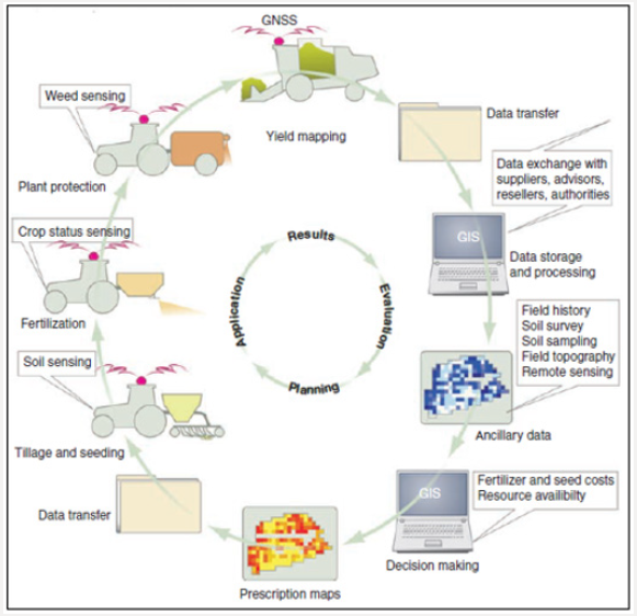
Figure 1: A typical crop growing cycle in precision agriculture [5] modified [4].
Lupinepublishers-openaccess-Agriculture

The precision agriculture, or the knowledge-based management of agricultural production systems, has emerged in the mid-1980s as a method for implementing the right process at the right time in the right place. The increased awareness of the variability in soil and product conditions has been combined with emerging technologies such as global navigation satellite systems, geographic information systems, and microcomputers. In the beginning, precision agriculture has been used to adapt the fertilizer distribution to the variable soil conditions in the agricultural area. Since then, additional applications have been developed, including the automatic steering applications of agricultural vehicles, autonomous machinery and processes, product monitoring, farm research and software for the general management of agricultural production systems. A typical crop growing cycle in precision agriculture is shown in Figure 1 [4].

Precision Livestock Farming

The first desired condition in animal production is breeding races with higher meat and milk yield. Second one is to make sure that the highest level of individual potential of animals is achieved through an adequate and balanced nutrition. The third is to take preventive health measures against diseases that cause the major losses in animal production and to minimize the use of drugs with the early detection of diseases and the necessary intervention [5]. Precision livestock production practices have contributed significantly to the solution of the problems experienced in animal breeding and in increasing the desired yield and quality in meeting the increasing animal food needs. Effective decisions are made by using precision livestock production practices in animal production and by monitoring individual animal conditions (amount of mobility, water consumption, milk conductivity value, amount of milk, etc.); necessary health measures are taken as soon as possible with the early identification of negative changes in animal health; and, sustainable and productive management is provided by ensuring that the individual potential of the animals is utilized at the highest level by making the herd management applications accurate and timely [6].

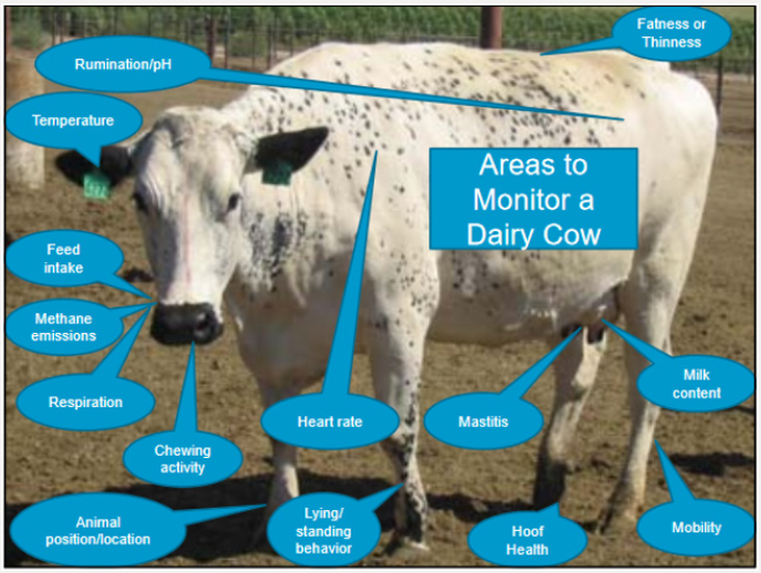
Precision livestock production allows collecting data at individual cow level as well as precision (individual) nutrition, regular milk recording (yield and components), pedometer, pressure plates, milk conductivity indicators, automatic oestrus detection, body weight, temperature, lying behavior, ruminal pH, heart rate, feeding behavior, blood analysis, respiratory rate, rumination time and movement skill scoring using image analysis. In this way, it minimizes drug (antibiotics) use and provides and proactive animal health strategy through preventive health by focusing on health and performance [7]. Benefits from precision animal production technologies include increased efficiency, reduced cost, improved product quality, minimized negative impacts on the environment and improved animal health and welfare. These technologies are likely to have a major impact on health, reproduction and quality control [8]. Figure 2 shows the areas observed in dairy cattle in precision livestock production.

Figure 2: The areas to monitor in dairy cattle in precision livestock production [9].
Lupinepublishers-openaccess-Agriculture

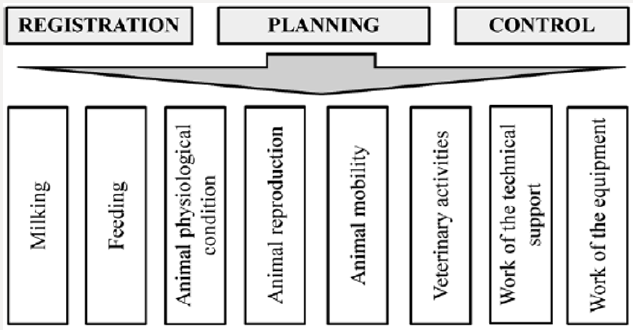
Figure 3: The tasks of the automated control systems for dairy farming [10].
Lupinepublishers-openaccess-Agriculture

Automatic control systems developed for dairy cattle farms provide solutions to the following tasks (Figure 3) [10]:

a) Getting the current information about animals;

b) Fast access to the animal history;

c) Increasing the milk yield because of the preclinical disease diagnosis;

d) Structure analysis of the herd and the animal physiological condition;

e) Reducing veterinary medicine costs;

f) Detection of the breaches in the herd reproduction technology;

g) Reducing the number of unpregnant animals and increasing the calf’s productivity;

h) Increasing the feeding effectiveness;

i) Reducing work costs and the improvement of work culture.

Autonomous Tractor

The concept of autonomous refers to the functions performed by the tractor without any human intervention. The concept of autonomous tractor and automatic steering should not be confused with each other. A tractor with automatic steering requires an operator for safety, avoiding unknown obstacles and performing unspecified tasks. An autonomous tractor can operate without the operator in overcoming the numerous uncertainties in the agricultural environment. In autonomous tractors, the necessary hardware and software are developed for obstacle avoidance, localization and mapping in addition to determining algorithms, models and methods for movement control. In order to implement route planning and navigation for this purpose, it is necessary to accurately estimate the position of the vehicle and to detect the environment sensitively during the movement of the vehicle.

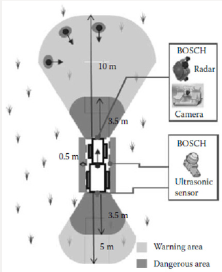
Figure 4: Safety sensor for an autonomous tractor [11].
Lupinepublishers-openaccess-Agriculture

Various equipment and systems are used to determine the position of autonomous tractors, to set the desired route correctly, and to map the obstacles and objects around correctly. The information collected from the sensors should allow the autonomous tractor to move safely. Since autonomous tractors operate in outdoor and in diverse environments, errors may occur due to inability to receive information from some of the sensors or due to the errors in the information received. For this reason, it is preferable to process the data from different sensors together and unique advantages of the different types of sensors are used together to obtain a more comprehensive perception (Figure 4). In this way, the information from the sensors provide more detailed information about the location, environment and surrounding objects during the movement of the tractor. And, in order to turn this information into useful information, advanced decision mechanisms, utilizing applications such as image, audio and video processing algorithms, neural networks, machine learning, statistical data analysis, are used and the autonomous tractor is operated successfully in this way. The equipment used in autonomous tractors are listed below:

a) Radar Sensors

b) Laser Scanners,

c) Lidar,

d) GPS / Inertial Navigation System,

e) Ultrasonic Sensor,

f) Cameras.

When developing an autonomous tractor, combining a large number of tasks to increase operational success will relatively facilitate the task. These tasks include [12]:

a) Coordination: The coordination of multiple vehicles can be done centrally. Each vehicle operates independently and does not know necessary information about other vehicles, but it has its own tasks to fulfill.

b) Solidarity: Solidarity refers to the awareness of multiple vehicles, working in the same field, from each other and tasks of the others. For example, if three vehicles carry out the same task, such as clearing the same area from the weeds mechanically, then each vehicle needs to know the rows in which other vehicles were running before selecting a new row to begin. It would not make sense to have two vehicles come to head-to-head at the same time. Real-time communication is needed between the paired vehicles.

c) Cooperation: It refers to multiple vehicles sharing the same task at the same time. Using multiple vehicles to pull a large trailer that a vehicle cannot pull alone is an example of cooperation.

Agricultural Robots

Agricultural robots are classified as indoor and outdoor robots, in general. Outdoor robots include GPS assisted steering systems, meadow robots, pruning robots, spraying robots, seeding/planting robots and silage robot. Indoor robots include harvesting robots, milking robots and barn robots [13]. Autonomous agricultural robots are now an alternative to tractors in the fields. Breeding operations can be carried out by the fleets of autonomous agricultural robots in the future, such as seed sowing, spraying, fertilization and harvesting robots. Agricultural robots must have some basic capabilities and the ability to support multiple applications. A navigation system is required for safe and autonomous navigation as a basic capability [14]. When different applications of autonomous vehicles in agriculture have been compared with conventional systems, it has been found that the first three main groups of potential practical applications include plant cultivation, plant care and selective harvesting [15].

In the last two decades, special sensors (machine vision, GPS, RTK, laser-based devices and inertial devices), actuators (hydraulic cylinders, linear and rotary electric motors) and electronic equipment (embedded computers, industrial PC and PLC) have integrated into numerous autonomous vehicles, especially the agricultural robots. These semi-autonomous/autonomous systems provide correct positioning and guidance in precision agricultural tasks, when equipped with appropriate equipment (agricultural tools or equipment) [16]. Field map can be generated by estimating the location of the plants in the surrounding environment through image processing and recorded data detected by sensors. The position estimation of the robot can be done by a navigation system or relative calculation of the movements of the robot. The distance of the plants to the robot can also be detected by sensors or image processing, and the calculated positions can be marked on a map [17].

The Use of Unmanned Aerial Vehicles in Agriculture

Aerial vehicles that can operate through remote control or autonomously with its own power system, and that can load and unload payloads depending on the place of use are called Unmanned Aerial Vehicles (UAV). There are two types of aerial vehicles, including UAVs that can fly autonomously on a certain flight plan and remote controlled drones. Although these vehicle names are commonly used interchangeably, the term UAV is a general term for all unmanned aerial vehicles, whether autonomous or remotecontrolled.

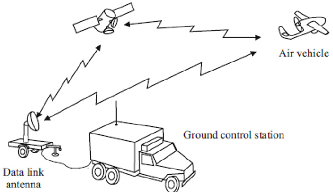
A typical UAV system consists of the aircraft, one or more ground control stations and/or mission planning and control stations, payload and data connection. In addition, many systems include launch and recovery subsystems, aerial vehicle carriers and other ground services and maintenance equipment. A very simple general-UAV system is shown in Figure 5. Being more complex and having more parts than drone systems increase [18] the cost of system installation of UAVs. In drone systems, however, drones can be used immediately after purchasing drones together with the apparatus without the need for any other costs. Due to the lower cost of purchasing than the UAVs, their ease of use and their capabilities, drones are preferred in agricultural applications.

Figure 5: Generic UAV system [18].
Lupinepublishers-openaccess-Agriculture

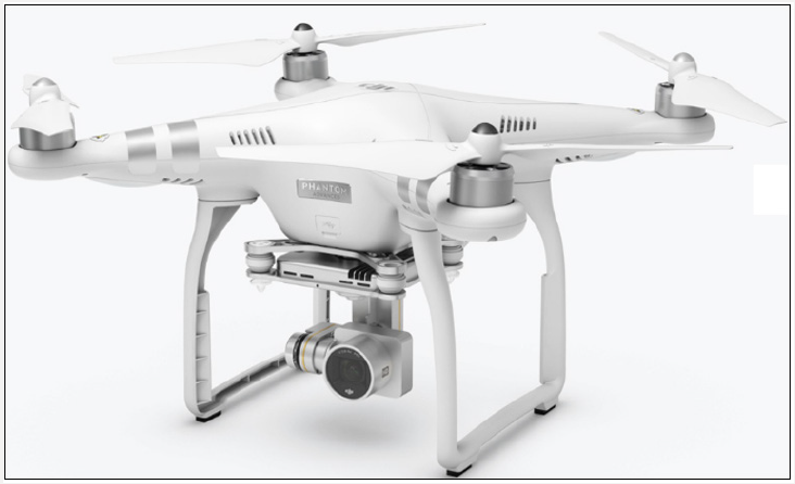
Drone systems provide fast and safe solutions and analysis for numerous situations, particularly for military applications, including natural disasters, monitoring of various sports activities, traffic control, wildlife monitoring, and agricultural applications. Therefore, drone systems are produced in different formats according to their area of use. One of the most preferred applications of drone systems is the four-rotor drone system known as the quadrotor shown in Figure 6. Quadrotor, as the name suggests, is a general term of the drone systems with four independent rotors. The most important advantage of the quadrotor is its high maneuverability. This superiority gives the quadrotor the capability of vertical takeoff and landing in dangerous and confined spaces. Due to the highpower consumption of four rotors of a quadrotor, it cannot perform long-term flight duty. The capacity of the device can be increased by increasing the number of rotors. Six-rotor hexacopters and eightrotor octocopters are the examples of different forms of quadrotor obtained by increasing the number of rotors [19].

Figure 6: Four-rotor drone system [20].
Lupinepublishers-openaccess-Agriculture

Increasing productivity and improving product quality in agricultural production depends on good monitoring of the plants’ development process and taking the necessary actions at the most appropriate time. Drone systems, which have a simple technical structure and are easy to use, offer farmers an opportunity to make plans in agricultural activities using their embedded sensors and cameras, providing high quality and 3D images. Varies studies are carried out with drone systems, such as product development monitoring, plant species separation, crop harvest determination, automatic harvest, drought, detecting diseases, agricultural pests, etc., damage detection, fruit and vegetable and soil moisture classification, field management, organization of agricultural activities, and agricultural insurance [21].

Drone systems have 5 effective use areas in agriculture. These are [22]:

a) Product status monitoring: Farmers can inspect their growing products faster and more effectively with drones with NDVI or NIR sensors.

b) Irrigation systems monitoring: Large enterprises are able to monitor irrigation systems for the supply of water needed for certain products such as corn, which are spread over large areas, after having reached specified sizes.

c) Weed identification: Weed maps are generated by postprocessing the flight images and NDVI sensor data. In this way, farmers can easily distinguish between high density weeds growing together with healthy plants.

d) Variable rate applications: Variable-rate maps are rapidly and practically generated with the use of NDVI sensors in drone systems, instead of using variable-rate application maps prepared by ground-based or satellite images. In this way, it is possible to increase the efficiency by decreasing fertilizer costs.

e) Herd management and monitoring: The amounts and activity levels of free-bred ovine or bovine animals can be monitored from above through a drone.

Conclusion

Agriculture is a vital industry due to its contribution to the sustainability of lives of people, to national income and employment and its provision of raw materials to other industries. Therefore, the agricultural sector has a direct impact on all segments of the society with its economic, social and environmental dimensions. Economically, subjects such as increasing agricultural production and farmer revenues, minimum use of production inputs, improving marketing conditions, etc. are addressed. Socially, there are topics such as food quality and safety, agricultural employment, socio-economic sustainability of rural areas, animal welfare, etc. And, environmental issues include biodiversity, protection of wildlife, meadow-pasture, forests, underground and surface waters, and soil resources. Utilizing the opportunities offered by advanced technologies is becoming increasingly mandatory in order to achieve high success in studies conducted on all these comprehensive issues, due to the importance of the subjects and difficulties involved.

For more Lupine Publishers Publons Click on Below link


Friday, February 12, 2021

Lupine Publishers | Dimethyl ether as Zero Emission Fuel-Synergies with Biogas and Biomass Plants

    Lupine Publishers |Agriculture Open Access Journal


Introduction

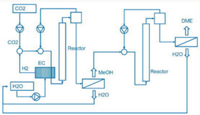
In Iceland a methanol plant named in honour of the noble prize laureate [1] operating since 2011. As substrate they use carbon dioxide and hydrogen producing methanol. Methanol is the simplest alcohol and well know since the developments of Paul Sabatier and the catalysis processes [2], in liquid phase at environment pressure and temperature, and is a synthetic alcohol. In the Georg Olah Plant [3] carbon dioxide and hydrogen are mixed 1mol:3mol together to form a syngas, being compressed and transformed under the help of catalysts to methanol (methanol synthesis).

.
Lupinepublishers-openaccess-Agriculture

In most processes the methanol synthesis is running at a pressure range 30 bar up to 100bar and a temperature range 200 °C up to 400 °C. The conversion rate is given in the range of 25% up to 35% and therefor recycling of the unconverted gas in the methanol reactor back, to increase the conversion rate of synthetic gas and production rate. Leaving the methanol reactor, the product gas will be cooled down andthe condensate mixture of water and methanol is distilled and separated into water and product methanol. The methanol synthesis with carbon dioxide hydrogen is needed, generated by wet electrolysis.

Lupinepublishers-openaccess-Agriculture

Figure 1: Methanol and Dimethyl ether from carbon dioxide and water.

Lupinepublishers-openaccess-Agriculture

From water and the electric power needed for the electrolysis is generated by geothermal heat conversion to electricity (Figure 1). This is a special property of Iceland. Now the question arises, where does the carbon dioxide come from? In the most common case. Carbon dioxide is separated from exhaust gas from fossil fuelled power plants and industrial processes. Using fossil carbon dioxide in plant process the George Olah plant [3] is now accelerating the consumption of fossil fuels if we use methanol as a fuel. Therefor methanol should be used in chemical industry fixing carbon dioxide [1]. But if we use methanol as fuel in transportation, the combustion of methanol leads to carbon dioxide and water being transferred to normally carbon dioxide transferred to the environment is a dilution of carbon dioxide in the air. We watch that methanol burned in a classical Otto motor cycle additional produces compared to fossil diesel fuel in a diesel engine higher pollution, dust, soot and a higher amount of carbon dioxide in the exhaust gas. Therefor methanol is converted to dimethyl ether by extraction of water under acid conditions [4,5].

Lupinepublishers-openaccess-Agriculture

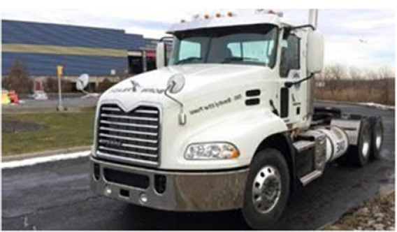
Dimethyl ether is often mentioned as the ideal Diesel fuel [8], tested over long years from VOLVO [6] and by MACK TRUCK [7] in heavy trucks on the road. Dimethyl ether is the simplest ether a synthetic fuel, certificated by the ISO 16 681:2013 by the IDA, produced from methanol or by direct synthesis (Figure 2).

Lupinepublishers-openaccess-Agriculture

Figure 2: Mack truck testing Dimethyl ether.

Lupinepublishers-openaccess-Agriculture

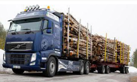
In most cases there is no application of methanol in transport, civil, agriculture and forestry, because they are running on fossil diesel. Heavy strong robust power machines are needed and the diesel engine is the ideal power machine. Methanol cannot substitute fossil diesel directly. But dimethyl ether has this needed property. As shown from MACK TRUCK (New York) [7] testing Dimethyl ether in heavy trucks [7]. Since VOLVO (Sweden) [6] started in using Dimethyl ether in heavy trucks in 2008, running over five years the trucks on the road (Figure 3), and moved then to the USA at MACK TRUCK [7], it is well known that dimethyl ether is a story of success and dimethyl ether is the ideal Diesel fuel [6,7].

Figure 3: VOLVO heavy truck running on Dimethyl ether.

Lupinepublishers-openaccess-Agriculture

Ethanol, Biodiesel

Using corn from agriculture bioethanol is produced with fermentation. Corn is a food product not agricultural waste. Bioethanol has the same combustion and emission problem as methanol: it can only be used in a gasoline engine and leads to higher pollution, lower efficiency, soot dust, and high carbon dioxide than dimethyl ether. In Europe biodiesel is mixed with fossil diesel. Biodiesel is produced from oil and fatties over catalytic esterification, but again biodiesel has the same combustion problem as methanol: although biodiesel can be used in diesel engines, biodiesel leads to higher pollution, lower efficiency, soot dust, and high carbon dioxide than dimethyl ether [6].

Biogas

The anaerobic fermentation process enables to produce biogas, consisting of methane and carbon dioxide (CH4, CO2). Biogas can be produced from wet biogenic waste. The anaerobic process can be realized in wet phases or in dry phases but always lead to biogas and digestate, which can be recycled again. In most application biogas is used to generate electricity and heat. The electric efficiency of biogas engines is 30% up to 36%, and we have an exhaust gas, therefore no zero emission.

Forestry biomass

In Forestry wood is used for pulp and paper and for wood in civil and industry. Generating heat from wood chips with a warm water boiler is well known. In the most application biomass is used to generate heat. The thermal efficiency is low 75% up to 85%, and we have an exhaust gas and again no zero emission.

Reforming and gasification for dimethyl ether

Dimethyl ether can be produced from biogas and biomass. Biomass as waste biogenic mass can be used for gasification to generate synthetic gas and char coal. The char coal is carbon, the synthetic gas consists of CO:23%, H2:20%, CH:1%, O2 <0.1%, CxHy: 3%, Rest CO2. The heat caloric value is about 1.5kWh/m³. Charcoal can be reused again and converted to syngas over the known water gas reaction

Lupinepublishers-openaccess-Agriculture

Biogas can be used to generate synthetic gas with dry reforming:

Lupinepublishers-openaccess-Agriculture

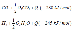
The synthetic gas consists of CO:40%, H2:40%, CH:3%, O2< 0.1%, CxHy: 1%, Rest CO2. The heat caloric value is about 2.5kWh/ m³. In both cases syngas can be transformed to dimethyl ether over direct synthesis: 3CO + 3H2CH3OCH3 + CO2 + Q (- 254kJ/mol).

Hydrogen

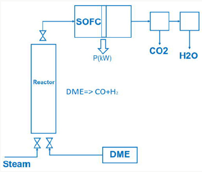
Figure 4: Dimethyl ether and SOFC Cycle.

Lupinepublishers-openaccess-Agriculture

Cheap hydrogen is the basic requirement for the production of cheap and competitive dimethyl ether from methanol (Figure 4). Hydrogen from electrolysis costs electric power ~5.0 kWh/m³ H2. Hydrogen generated from waste heat, enables to split water into hydrogen and oxygen with metals at temperatures from 400 °C up to 800 °C:

Lupinepublishers-openaccess-Agriculture

SOFC or thermionic and magneto hydrodynamic Generator Using dimethyl ether in a SOFC (solid oxide fuel cell) cell dimethyl ether has to be converted to syngas by steam reforming

Lupinepublishers-openaccess-Agriculture

The exhaust gas from the SOFC cell consists of carbon dioxide and steam.

Lupinepublishers-openaccess-Agriculture

SOFC cells operate in a temperature range 800 °C up to 1000 °C, at nearly environment pressure and have an electric efficiency of 50% up to 60%. Another possibility is to generate heat with combustion of dimethyl ether in a metal oxide reactor.

Lupinepublishers-openaccess-Agriculture

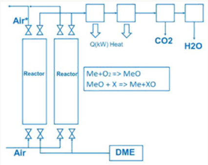
The generated heat can be direct converted to electric energy with a thermionic generator. Thermionic generators have an electric efficiency from 25% up to 35%, combined with magneto hydrodynamic generators having an electric efficiency from 30% up to 40%, we gain in sum from 55% up to 75% for the direct conversion of heat to electric energy (Figure 5). In both applications we oxidize dimethyl ether to carbon dioxide and water under pressure up to 50 bars.

Lupinepublishers-openaccess-Agriculture

Do that the exhaust gas consisting of carbon dioxide and steam can be collected as condensate in different tanks. This enables carbon dioxide and water to be reused in such plants like the George Olah Plant [3] and Oberon plant [4] again. The step of collecting carbon dioxide and water is the closure of the methanol over the dimethyl ether processes. It is now a closed cycle collecting carbon dioxide in a tank wo be recycled to methanol and dimethyl ether process again. This closed cycle now reduces the emission of greenhouse gas like carbon dioxide and can be seen as a sustainable property of the carbon dioxide recycling. Carbon dioxide now is a substrate and a basic part in the fuel production and not a pollution in the exhaust gas anymore. Under this conditions carbon dioxide and the emission certificates connected to carbon dioxide can be used in a global trade [8].

Figure 5: Dimethyl ether and high temperature heat generation.

Lupinepublishers-openaccess-Agriculture

Closing the cycle

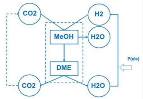
To reach zero emission we must convert Dimethyl ether into carbon dioxide and water. Carbon dioxide and water can be converted back (recycled) to dimethyl ether with electric energy and heat. Under this cycle we generate only this amount of carbon dioxide, connected with dimethyl ether. Using more dimethyl ether enables to reuse more carbon dioxide and the process is acting like a carbon dioxide sink. Focusing on this property of zero emission enables to save energy and substrate in agriculture and forestry, in civil and transportation (Figure 6). Using waste from agriculture and forestry, using biogenic waste from hotels, food industry and biogenic waste from municipal and civil waste, reduces the pressure on new and fresh biomass, reduces the pressure on fossil substrates. Under the property of zero emission the methanol cycle of the George Olah plant [3] will be renewable and also the dimethyl ether plants of Oberon [4,9].

Figure 6: Dimethyl ether closed cycle.

Lupinepublishers-openaccess-Agriculture

For more Lupine Publishers Social Bookmarking Click on Below link
https://issuu.com/lupinepublishers-oaj/docs/lupine_publishers_social_bookmarking_sites.docx

Monday, September 7, 2020

Lupine Publishers | Resistance of Laminated Veneer Lumber (LVL) Produced from Rubberwood, Radiata Pine and Larch Against Subterranean Termites And White Rot Fungi

 Lupine Publishers |Agriculture Open Access Journal


Abstract

Laminated veneer lumbers (LVLs) were fabricated using rubber wood, radiate pine and larch wood. Solid rubber wood was used to serve as control for comparison purpose. All of the wood samples were exposed to subterranean termites and white rot fungi for durability evaluation. The results showed that rubber wood LVL had the highest resistance against both deterioration agents in comparison to control, confirming that the resistance of non-durable wood species could be improved by converting them into LVL.

Keywords: Termites resistance; Fungal resistance; Low density wood; Hardwood; Softwood

Abbrevations: LVL: Laminated Veneer Lumber; PF: Phenol Formaldehyde; AWPA: American Wood Preserves Association; ANOVA: Analysis of Variance; SPSS: Statistical Package for the Social Sciences.

Introduction

Improper forest management and the rapid population increment have induced the continuous growing of timber demand and subsequently led to timber resources depletion around the world. The supply of high quality raw timbers with large diameter is declining accompanied by increasing timber price due to the aforementioned matter. Rising timber costs had shifted the manufacturer’s attention from solid sawn wood to engineered wood products, for example, laminated veneer lumber (LVL). In order to attain better compression and higher strength of LVL products, wood with lower range of densities are often being used. In US, LVL has been typically constructed from southern pines, western softwoods and yellow poplar [1], while in the case of Malaysia, rubber wood are the most common used materials owing to its readily availability. Never the less, one of the disadvantages of these low density wood species is their poor durability against deterioration agents such as termites and fungi. Therefore, better durability could be anticipated by converting these low density wood into LVL bonded by phenol formaldehyde (PF) resin as PF resin has long been recognized as an effective way to enhance the wood properties [2,3]. To the author’s knowledge, there is little or no information regarding the resistance of LVLs fabricated form low density hardwood and softwoods such as rubber wood (Hevea brasiliensis), radiata pine (Pinus radiata) and larch (Larix spp.) against both subterranean termites ((Coptotermes curvignathus Holmgren)) and white rot fungi (Pycnoporus sanguineus). Therefore, this study evaluates and compares the biological resistance of LVLs fabricated from rubber wood, radiate pine and larch with that of solid rubber wood.

Materials and Methods

Nine-ply laminated veneer lumber (LVL) having a dimension of 200 mm longx50mm widthx10mm thick was supplied by Wood Research Institute, Kyoto. These LVLs were fabricated from rubber wood, radiata pine and larch wood using phenol formaldehyde (PF) resin as binder. Solid rubber wood was used as control in this study for comparison purpose. For resistance tests, subterranean termites (Coptotermes curvignathus Holmgren) and white rot fungi (Pycnoporus sanguineus) were used. The termites were collected from Bukit Expo, University Putra Malaysia using pine blocks as baits. A total of 40 samples, five samples for each material used, were assigned to both resistance tests (4 materials (solid rubber wood, rubber wood LVL, radiate pine LVL and larch LVL) x2 resistance tests x5 replicates). LVLs and solid rubber wood were cut into dimensions of 20x20x10mm prior to the tests. Termite tests were conducted in accordance to American Wood Preserves’ Association (AWPA) Standard E1-13. 200g of sterilized sand mixed with required amount of distilled water were added into a culture bottle. Each test block was exposed to approximately 1±0.05g of termites comprising 10% soldiers and 90% workers. The cultured bottles were then wrapped with black paper and kept at the room temperature (25±2 ̊C) for 4 weeks. The cultured bottles were examined daily to record the mortality rate of the termites. After 4 weeks of exposure to termites, the test blocks were removed and conditioned until they reached constant weight. The mass of the blocks was weighed and the percentage of weight loss was then calculated using Equation (1).

Weight loss(%)=((Wa-Wb)/Wa)x100 (1)

Where Wa = conditioned weight of the test block before exposure (g) and Wb = conditioned weight of the test block after exposure (g).

The mortality of termites was calculated using the following equation:

Mortality (%) = (Number of dead termites / initial number of termites) x 100 (2)

Decay resistance test against white rot fungi was carried out according to American Wood Preserves’ Association (AWPA) Standard E10-12. LVLs and solid rubber wood were cut into dimensions of 20x20x10mm prior to the test. The cut test blocks were then sterilized in an autoclave at 121 °C for 1 min. Next, the sterilized test blocks were placed on mycelium covered strips and kept in capped culture bottles. The culture bottles were incubated at temperature of 25±3 °C for 12 weeks. At the end of the incubation period, the test blocks were carefully removed and the mycelium was brushed off. The blocks were then conditioned in a conditioning room and weighed once the blocks reached constant mass. The extent of the fungal attack will be expressed as percentage of weight loss using Equation (1). The effects of materials used on termites and fungi resistance were analyzed using statistical package for the social sciences (SPSS) procedure for the analysis of variance (ANOVA) at 95 % confident level (P≤0.05). The significant level of the mean values was further analyzed using Duncan’s multiple range tests.

Table 1: Termites’ mortality rate and mean weight losses of samples against both termites and white rot fungi.

Lupinepublishers-openaccess-Agriculture

Means followed by same letters in the same column are not significantly different at P≤0.05; ±=SD

Results and Discussion

The average weight loss of sample blocks caused by both termites and white rot fungi are summarized in Table 1. The mortality rate of the termites at the end of the test is also listed in the same table. From Table 1, one can see that the larch LVL had the highest weight loss against termites (81.8%), followed by radiate pine LVL (39.6%) and rubber wood LVL (6.1%), while 64.8% of weight loss was recorded in solid rubber wood. It was also observed that all termites (100%) in the culture bottles that contained rubber wood LVL and radiate pine LVL died after 4 weeks of exposure. 48% and 50% mortality rates were observed in the culture bottes that contained solid rubber wood and larch LVL, respectively, suggesting lower resistance against termite attack. Larch LVL had lost higher weight even compared to solid rubber wood, implying that larch wood is more preferred by termites and even in the presence of PF resin, it could still cause severe damage to the wood. This phenomenon could be explained by its lighter density among the materials that used in this study. Larch wood that used in this study has a density of 530 kg/m3, while rubber wood and radiate pine have density of 640kg/m3 and 600kg/m3, respectively. Logically, it is much easier for the termites to nibble softer wood like larch in comparison with harder radiate pine and rubber wood. Rubber wood LVL showed the highest resistant among the three wood species used and the reason could be due to the fact that rubber wood itself contains relatively high amount of formaldehyde content [4]. It is interesting to note that the resistance to termites was prominently improved by converting solid rubber wood to LVL. The fact that rubber wood LVL is more resistance to termites could be explained by the presence of PF resin in the glue line, which imparted some preservative properties to the LVL. Poisonous nature of the phenol and the toxicity of the free formaldehyde released during the exposure period might have caused the death of the termites [5].

According to Table 1, surprisingly, LVL made from radiate pine and larch wood had higher weight loss against white rot fungi (6.8% and 6.0%, respectively) in comparison to rubber wood LVL and solid rubber wood. These findings were in disagreement with Nilsson [6] who suggested that the higher susceptibility of hardwoods is due to their lower lignin content compared to that of softwoods. On the other hand, rubber wood LVL revealed better performance against white rot fungi compared to solid rubber wood, with weight losses of 0.7% and 3.9%, respectively. Similar to the findings against termites, the presence of PF resin might have some influence on the fungi preference. The cured PF resin is very hard and thus made it more difficult for the white rot fungi to grow on the edges of the LVL. Therefore, only the tangential surface was fully colonized by the fungi. Whilst in the solid rubber wood all of the four surfaces were colonized by the fungi resulting in more severe degradation.

Conclusion

Based on the weight loss and mortality rate, rubber wood LVL is the most resistant toward termites among the three species studied in the present work, followed by radiate pine and larch. By converting solid rubber wood to rubber wood LVL, the resistance against termites had improved approximately 10-folds owing to the presence of PF resin glue line which might have toxic effect against termites. On the other hand, both radiate pine and larch LVL are more susceptible to white rot fungi compared to that of rubber wood LVL. In the comparison between solid rubber wood and rubber wood LVL, once again, rubber wood LVL displayed better resistance against white rot fungi. Rubber wood exhibited a superior resistance ability might be due to several factors. One of the probable theories is that the rubber wood contains a substantial amount of formaldehyde which may provide a better resistance towards both termites and white rot fungi. Further study in quantify the amount of formaldehyde in all the wood species used in the study is therefore needed to be conducted to verified the above statement.

Acknowledgment

This study was financially funded by Higher Institution Centre of Excellence (HICoE), Institute of Tropical Forestry and Forest Product (INTROP), University Putra Malaysia.


For more Lupine Publishers Social Bookmarking Click on Below link
https://issuu.com/lupinepublishers-oaj/docs/lupine_publishers_social_bookmarking_sites.docx

Tuesday, August 20, 2019

Lupine Publishers | Assessment of the Application of Micro-Irrigation Systems and Calculation of the Definition of its Economic Efficiency in the Conditions of Azerbaijan

Lupine Publishers | Agriculture Open Access Journal

Annotation

For a well-known purpose in 2010-2015, Guba-Khachmaz RAEM, Tartar and RAEM Shamakhi TSB have been confirmed by numerous research findings in the field of mountain watering, in terms of the development of irrigation, the mountainous slopes include soybean, sugar beet, trees, and germination (barley, wheat, etc.), the microcirculation method was not cost-effective in terms of efficiency, and preventive measures such as surface soil wash, sliding, irrigation and drowning, erosion characteristic for mountainous terrain zones , which is of particular importance, confirms the feasibility study of the farm calculated with the following formula.
Keywords: Leakage, Micro-irrigation, Investment,Bringing costs, Irrigation

Introduction

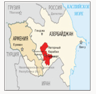
(Figure 1) Rapid growth of the world population, limited land plots, lack of fresh water resources, environmental degradation, climate variability and so on. problems have highlighted the problem of food humanity, which in turn requires proper regulation of land protection and improvement of the public administration mechanism of land resources. From this point of view, 60% of the land with difficult relief and complex natural climatic characteristics has been eradicated from the threatened state of the intensive development of mountainous zones and has been partially implemented in order to rehabilitate the fertility of these areas in the direction of agricultural destination, The scientific and economic importance of irrigation irrigation systems for progressive water is an undeniable fact. In this regard, it is aimed to calculate the effectiveness of these irrigation systems with more accurate method and methodology. The calculation of the economic efficiency of the use of the microscopy in terms of production experience with respect to the application of the application of the microscopy is considered to be one of the key factors.
Figure 1:
Lupinepublishers-openaccess-Agriculture

The Course of the Study

In accordance with the methodology for determining the importance of the application of new techniques and technology applied to the existing agricultural sector, the annual economic benefit obtained by the application of sugar beet micro-gradient is as follows:
Equation 1:
Lupinepublishers-openaccess-Agriculture
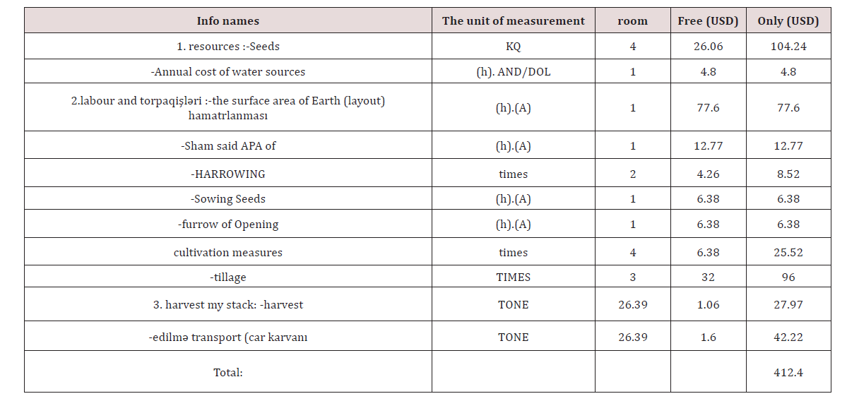
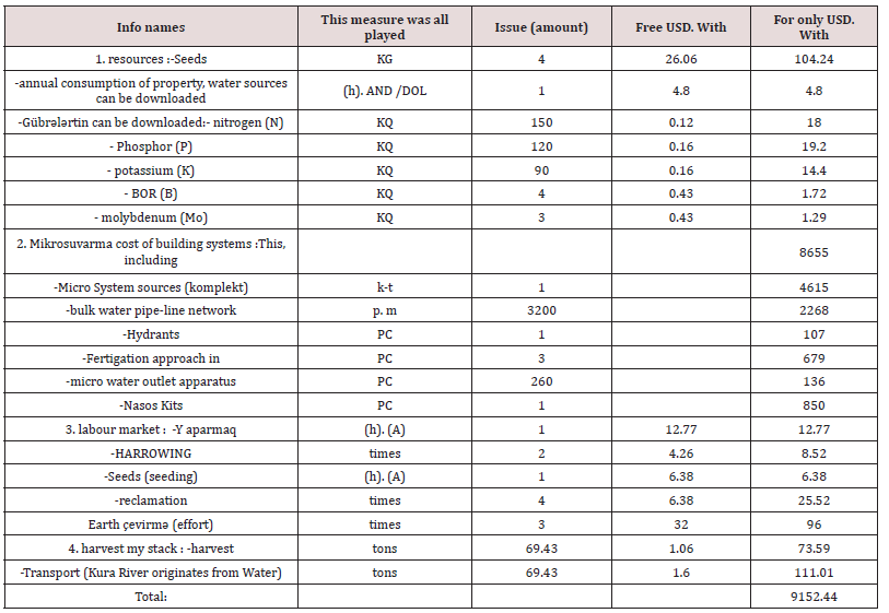
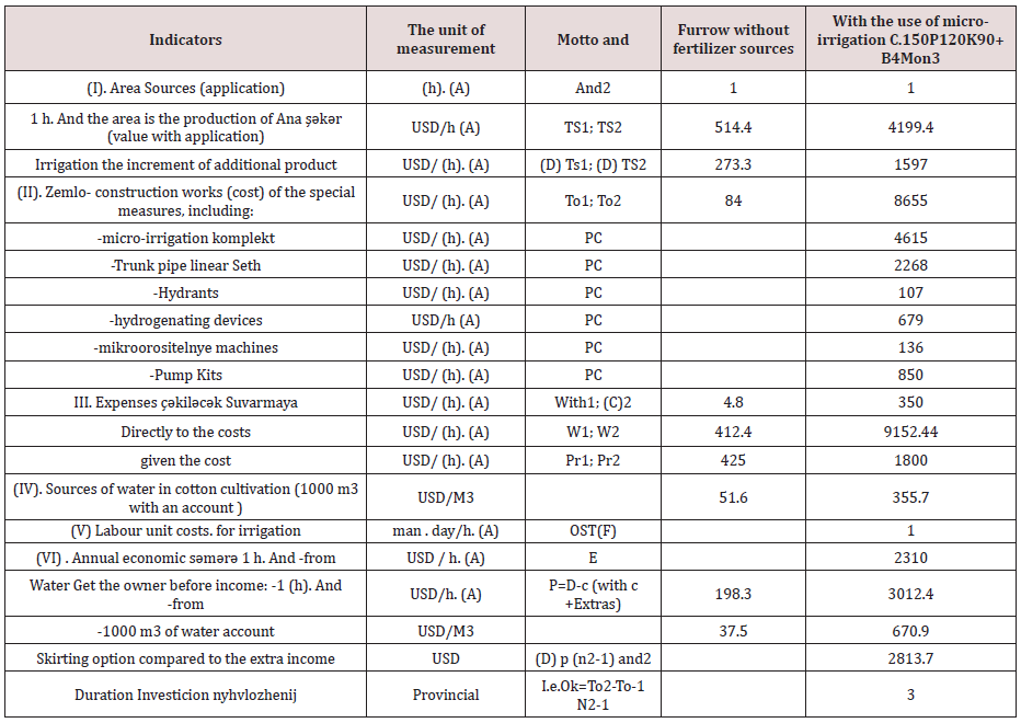
here w1 and w2 [1] hectares base case and new sources for the introduction of products owned by agricultural practices directly with the account mentioned costs; with USD. TS TS and -1 hectares base case and new sources of agricultural techniques involved, giving accounts belonging to the production plant; from USD. And [2] -annual volume applicator, ha. He compared to the sources of new methods for sufferers of traditionally implemented furrows watering sources. Ammortizasiya countries, major industrial distribution ammortizasiya popular norma and fond of Shamil running costs and repair costs in “Sojuzvodproekt”-n recommendations methodological guidance mainly accredited [3]. And studied at the settlement, belonging to the current irrigation natural indicators (parameters) Importance of the importance of Daka important elements in analysis. Micro-irrigation’s a series of hail shower processes physiological Mammary sugar, basic version compared to 20% to stimulation, he believes qn (cf. 1). From the table, July-October, months hang sources. This product is comparable to a 32.4% microscope option and down to the country’s product range of 54.3s/ha. In this difference, serious sources of water are effective (Table 1). This is the largest amount of supplies in the United States dollars volumesopposite or complementary sources of water is to take prices production Shehzad (increment) is generally characterized by (Table 2 ). Table 2 also available with situations mentioned, mikrosuvarmada/1 cents to get additional product name şırım Deng with sh 2-2, 5 times less water to spend relatively olunurki and that the sources of saving water [4]. Economic comparative efficiency sources for questioning, is the microelements macro and cotton from sugar beet using micro-irrigation with an additional set of products that have been achieved before Wahid overloaded costs the cost of establishing the system of mikrosuvarma, according to the variant set of products in production costs (labor, land cultivation) taken into consideration and s. (Tables 3 & 4). the report results Table 5-inch Micro-irrigation is generally characterized by observable short produced sugar beet , Ana Rajendra indicators during PA effectiveness will depend on several noted:
Table 1: Effect of yield of sugar beets from Micro-irrigation.
Lupinepublishers-openaccess-Agriculture
Table 2: Sources of water in the production of effective use of for sugar beets (July-October months average).
Lupinepublishers-openaccess-Agriculture
Table 3: According to agricultural cultivation and maps of harvest sugar beets.
Lupinepublishers-openaccess-Agriculture
Table 4: According to agricultural cultivation costs spent cards and harvesting of sugar beet.
Lupinepublishers-openaccess-Agriculture
Table 5: Economic evaluation of sugar beet micro-irrigation.
Lupinepublishers-openaccess-Agriculture
a) New Micro-irrigation technology application gives you the opportunity to increase the sources of water this means 90%, so the sources of water for more than 2 times in savings;
b) Labour cost fee-owned SH 3 has dropped from more than times;
c) Traditional furrow irrigation sugar beets is compared with an embedded micro-irrigation systems from annual economic income of $959.6, for reality in 3’s provinces from additional 1 hectare reclaimed area average investment return in the year.
Ecology of economically reliable, efficient and economic point reasonable are one of the sources who develop it worshipped the mikrosuvarma experience scientific institutions in our country system, produced the social sphere, pole təsərrüfanlarında and other qurumlarında to be self-sufficient it is spread wide, this mountain was regarded [5] agriculture as sources to use to obtain ownership of agricultural bitkilərindən Ecology of the retrieval of a set of products enables you to clean it. Now 25 metres below according to main, Nagorno positions in the zone zonada duties YAP torpaqlarında area management and mikrosuvarmanın economic efficiency identification and here is the production they created new gardens and Vineyard development of Fame main götürülərək system applied to them economic to be evaluated. That’s on top of research appointed economic efficiency will depend on several, which Yao 0.5 ha area Shamakhy region Soil a new worked asked Alma and pears arrested for ties and studied. Economic efficiency here is never possible. So that, a new 2-3 only after liberation and other in the morning pears GH property [6].
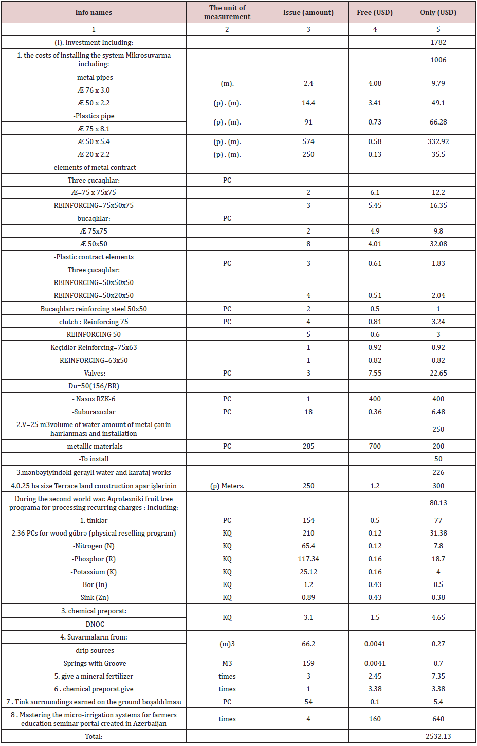
But despite this, they separate the option of economic efficiency of alloy conditions, shrink microwave for conditions for şəraitləri conditions comparative effectiveness of efficiency (roofing, lubrication, cultivation of agrotechnical program, the establishment of the microwave system sources and costs and phenology on the economic implications of the observed comparative effectiveness of efficiency fully aware. Table 5 mikrosuvarma ((roofing, lubrication, etc.) creating a system of actual expenditures and for fruit (pears) proqrama cultivation of agrotechnical program for current expenditure. Information that, 1 ha of orchards in the establishment of the microwave system you want to belong to the largest expenses 1006 USD. Use this operation despite the expenses without electric power less than many water sources explains, because that same value (1m3 in 0.0041 dollars) compared to 0.27 against $. irrigation is equal to $0.7. Low intensity (Dadia wildlife sources incarnation) sources, sources of water systems using in roaming which as a result of the current 2.6 2.4 times too low expenses time reduction seconds. At the same time, low intensity sources bathing condition unlike the reserves compared with in the ground present in tree fruit thanks to physiological activity stimulates moisture [7] (Table 6).
Table 6: Effect of yield of sugar beets from Micro-irrigation.
Lupinepublishers-openaccess-Agriculture
Note
a) Low-intensity (micro drip irrigation sources hot and s.) the establishment of a system of recurrent expenditure sources really $606 is because locking-pumps 400 USD, establish stocks of some unwinding of the following. This natural water in the summer, it is considered that the lack of ownership of water scarcity in the country, its water will be used from another source (small reservoirs) necessary.
b) ASMO is an integral part of the technology systems for automated control system is not given for free, so, in a small area and also in the objects of study due to its great expense and it is not installed in the system account is not maintained Therefore, the record

https://lupinepublishers.com/agriculture-journal/pdf/CIACR.MS.ID.000140.pdf

https://lupinepublishers.com/agriculture-journal/abstracts/assessment-of-the-application-of-micro-irrigation-systems-and-calculation-of-the-definition-of-its-economic-efficiency-in-the-conditions-of-zerbaijan.ID.000140.php

For more Lupine Publishers Open Access Journals Please visit our website
For more Agriculture Open Access Journal articles Please Click Here:
To know more about open access publishers click on Lupine Publishers.

Wednesday, July 31, 2019

Lupine Publishers| Agriculture Open Access Journal


Abstract

The evolution of remote sensing techniques, the rising availability of increasingly accurate and reliable technologies and the widening provision of precise and detailed data constitute the framework within which more and more specific sectors use remote sensing. Agriculture is one of the sectors where different applications of remote sensing can prove their effectiveness as they offer the possibility of gaining new perspectives, detecting phenomena not visible from the ground and in replacing man when inspecting territories dangerous, contaminated or difficult to access is necessary. Present paper aims to illustrate remote sensing techniques currently available in olive growing, highlighting their advantages in terms of optimisation of production processes and natural resources exploitation, environmental footprint, traceability of final products and monitoring of yield.
Keywords: Olive growing; Remote sensing; Satellite data; Unmanned aerial vehicle (UAV)

Introduction

Remote sensing is a set of techniques that allows the exploitation of different way in which natural surfaces interact with electromagnetic energy from a source to obtain information about their characteristics. Until a few years ago, data and images could be acquired just by aircraft equipped with special cameras whose use had to be designed in detail with considerable expenses and difficult replicability of acquisition. In recent years, data acquired by satellites have become available and later continuous technological evolution has made it possible to perform the same service at even higher resolution through unmanned aerial vehicle (UAV), allowing considerable cost savings and, most importantly, making this technology no longer an exclusive prerogative of scientific community. At present the choice of instrument depends essentially on the costs and on the level of detail desired. Using UAV, increasingly common and executable with different resolutions, still has a price justified only by large-scale projects; satellite data have a spatial resolution ranging from 10 m to 30 centimetres, suffer from interference such as the presence of the atmosphere and cloud cover but, at lower resolutions, are available free of charge. At present, the satellite constellations from which data and images can be drawn are different. Optical satellite images may have spatial resolutions (i.e., pixel size) of kilometres or even centimetres. In the case of free data, the spatial resolution is 20 to 30 meters on the ground and the most common are Landsat, Aster and Sentinel 2 and 3. Multispectral sensors such as Landsat, Spot, Quickbird, Aster, etc., have low spectral resolutions and therefore have bands of considerable amplitude; this does not allow good discrimination of spectral characteristics.
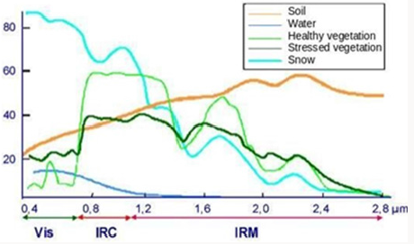
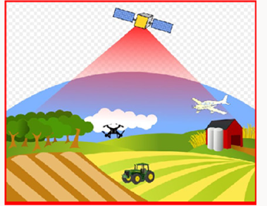
Instead, hyperspectral sensors (Mivis, Aviris, HyMap, etc.) have a better spectral resolution and allow to obtain a satisfactory discrimination of some absorption bands. In contrast, hyperspectral sensors do not have a wide coverage of the Earth’s surface and this is one of the reasons why multispectral sensors are preferred for different territorial applications. Remote sensing data with a high spatial resolution allow a considerable increase in investigation scale, with performances in terms of accuracy, comparable to those obtained with traditional aerial photogrammetric techniques. Increasing spatial resolution makes the detail of the object’s shape grow, but implies an increment of the parameters needed to describe classes (Figure 1). Normally, high spatial resolution with current satellite surveying technologies corresponds to a reduced spectral resolution, which prevents a detailed description of a surface based on energy measurements reflected. Moreover, satellite data with high or very high spatial resolution are hardly free of charge and for the case studies dealt with, which concern large scale areas, data with a wider spectral resolution (to the detriment of spatial resolution) were considered. Different data collection methods differ in terms of acquisition frequency, processing times and delivery timeliness. Although UAV acquisition can be programmed as desired while satellite images are acquired at regular intervals, the latters allow more complex elaborations based on the analysis of the available historical series. The utilization of UAV is not only limited to diagnostic context but also to practical applications: in Italy they have already been successfully tested in the biological treatment of maize against some kinds of lepidoptera; in Japan, instead, a large part of spraying with herbicides and fertilizers is carried out on rice paddies by means of small tanks implanted on drones which, depending on the parameters measured, dose their concentrations (Figure 2).
Figure 1: Spectral Signature.
Lupinepublishers-openaccess-Agriculture
Figure 2: Remote Sensing.
Lupinepublishers-openaccess-Agriculture
The increasing availability of powerful tools to improve the efficiency of agronomic practices and the increasing sensitivity to the environmental footprint of the agricultural sector are having an important impact in different parts of the world.In the European context, for example, the Dutch government has budgeted up to €1.4 million for the purchase of satellite data to improve sustainability and efficiency of agriculture. These data will include detailed information on soil characteristics, atmosphere and crop development. Specialised farms will be able to analyse them to provide farmers with targeted advice on irrigation, fertilisation and pesticide spraying activities. Satellite data will be open and starting from next seasonon dedicated platform (http://satellietdataportaal. nl), allowing everyone to have free access to the database. Dutch agricultural and horticultural sector enjoys a strong international reputation so the government wants to support this leading position by investing in innovation. Satellite data allow farmers to monitor crop progress very closely and take corrective action exactly where it is needed, resulting in greater efficiency and sustainability. Data purchased by the government will be analysed and processed by scientific institutes and specialised companies and then converted into information directly accessible to farmers, for example on the state of health of the vegetation (http://www.groenmonitor.nl) or on fertilisation and irrigation (http://www.akkerweb.nl). Smart methods and technologies will be able to generate significant savings for farmers in terms of fuel, seeds, artificial fertilisers, crop protection agents and water. Also FAO has recently developed software called Collect Earth that exploits the databases of Google Earth Engine, the portal thanks to which you can access millions of images taken by U.S. and European satellites, completely free and open source, in order to bring more and more users to satellite data to monitor territory, observe land and visualize their evolution.
Moreover it is not by chance that remote sensing techniques have significantly contributed to the creation of the Information System and the Territorial Database currently managed by AGEA, the Agency for Agricultural Disbursements, which since 1982 has started to acquire first aerial data for the establishment of the olive cultivation register (Reg. n°2276/79). This impressive and structured data collection is today one of the most important sources of information not only on the agricultural and forestry sectors but also on the definition of the evolution of land use and consequently the identification of land degradation phenomena.

Remote sensing and olive growing

More than 11 million hectares of olives are grown in the world, spread across the five continents, two hemispheres and 47 countries [1]. At present, olive oil is consumed in over 160 countries registering a production amounting in more than 2500 thousands tonnes2. These numbers are an indication of how important olive sector is for the economy of the 47 producer countries, and how much an efficiency of the production cycle and a reduction in its environmental footprint can benefit the entire terrestrial ecosystem. The application of remote-sensing techniques in olive growing may to contribute significantly to the increase in olive grove productivity and to the contextual reduction of the environmental impact of farming practices. They allow more specific and differentiated intervention according to the variability within an olive grove, thus allowing advantages to be obtained in terms of: a) Monitoring and optimization of fertilization and plant health protection operations on the basis of site-specific surveys. b) The most appropriate choice of irrigation method and quantity of water to be supplied depending on specific water demand; c) Evaluation of the morphological characteristics of the plants and planning of the most appropriate pruning operations; d) The estimation of olive productivity and subsequent oil yield. Once the purely cultivation phase is over, monitoring activities carried out with the support of remote sensing can also be useful for the traceability of final products (table olives and/or olive oil) and the consequent possibility of guaranteeing and certifying origin, cultivation regime (biologic, sod seeding, minimum tillage, etc.) and other information useful to make the consumer’s choice as aware as possible.
First high resolution applications have been made by integrating satellite images and probabilistic techniques for counting olive trees with the purpose to provide a support in surveying and inventorying forests and areas covered with other kinds of arboreal crops and, in particular for olive trees, in assessing estimates of the production of plantations [2]. With the same purpose of reducing considerably the effort of manual tree counting and providing a useful instrument for environmental applications of fruit orchard, plantation and open forest population monitoring, project called Arbor Crown Enumerator (ACE) was developed for tree crown detection from multispectral Very High-resolution (VHR) satellite imagery [3]. Using a combination of the Red band and Normalized Difference Vegetation Index (NDVI) thresholding, and the Laplacian of the Gaussian (LOG) blob detection method, this methodology is intended to replace the previous OLICOUNT software and to broaden its scope of application. OLICOUNT, a tool launched by the European Commission with the specific goal to estimate the number of olive trees in France, Italy, Spain, Portugal, and Greece, has automated this counting process to some extent and it has been an important reference in agricultural policies. It has been used, for example, to develop an olive tree registration in the framework of the database accession process to the European Union by the Turkish Government [4].
Reliable methods for the estimation of crown architecture is another key issue for the quantitative evaluation of tree crop adaptation to environment conditions as for an accurate 3D model of the tree crowns can provide information about critical aspects of plant growth and development and, therefore, about its suitability for some specific training systems. This is especially important in olive breeding programs aimed at developing new cultivars suitable either to discontinuous (open vase configuration) or continuous (hedgerow) canopy. Results from studies conducted acquiring data by means of consumer-grade cameras on board a UAV [5], show a high agreement between remote sensing estimation and field measurements of crown parameters. Torres [6] have carried out several tests to estimate exact volume of canopies through threedimensional processing of images acquired by drone on different kinds of olive grove (traditional and very high density). Results obtained, later compared with on the ground measurements, have highlighted some differences attributable to the in-field method of calculating volume. The equation conventionally used, in fact, considers trees as forms ellipsoidal, leading to inaccurate estimates due to excessive geometric simplification. This work, in addition to confirming the potential application of survey techniques by UAV, also provides an alternative methodology that can fill in application gaps belonging to traditional procedures.
Some remote sensing applications have been tested on large olive groves in order to determine the foliar area by indirect measurements and, on the basis of these, to evaluate presumed yield and to estimate exact volumes of plant protection products to be sprayed according to the foliar surface capable of intercepting the product itself (directly proportional to the foliar surface) and defining a correct pruning management strategy, in terms of intensity and rotation. A further interesting application by CNR and University of Florence’s researchers intended to simulate the olive-growing productivity through the integration of remote sensing and in-field data [7]. Multi-step methodology combines olive NDVI values with meteorological data within a parametric model that allows the estimation of primary productivity daily gross weight (GPP). Further elaborations and the use of a specific biogeochemical model allow them to estimate olive yield expressed in terms of quintals per hectare. This value, relative to the years in which the simulation was carried out, was then compared with data collected in provincial statistics showing the quality of the method developed and reproducing with satisfactory accuracy the inter-annual variation in olive yield throughout the whole region. Current climate change suggests that in many European countries, as in other parts all over the world, lack of adequate rainfall may be one of the major factors limiting agricultural production in general. For this reason, some applications have been developed with the specific aim of monitoring the water stress of crops and optimizing the use of water resources. One of these studies was conducted in Chile [8] and led to the design of a real Geo-Informatics System for Irrigation Management aimed to increase water productivity (kg/ m3) and to adapt agricultural systems to water scarcity. Water demand of olive trees as well as biomass production and, therefore, crop yield are directly related to the ability of plants to absorb and convert solar radiation.
In this framework, stand all the researches aimed at establishing two-way relations between the fraction of Intercepted Photo synthetically Active Radiation (fIPAR) and some kind of satellite index. Just for example, scientific studies carried out in Spain [9] investigated on the relationship between fIPAR and the Normalized Difference Vegetation Index (NDVI) using radiative transfer modelling methods and field measurements. In the field of disease detection some remote sensing-based efficient methods were developed for detecting eventual disease in early stages and for discriminating among severity levels in order to adequately calibrate the kind of intervention. Calderon [10], for example, assessed the potential of using vegetation indices for the early detection of the soil-borne fungus Verticillium wilt in olive orchards using indicators based on crown temperature (CWSI), visible ratios (B, BG, BR), and chlorophyll fluorescence estimates FLD3 to detect disease in earlier stages and structural multispectral indices such as Normalized Difference Vegetation Index (NDVI), PRI, chlorophyll and carotenoid indices for the detection of the presence of moderate to severe damage [11]. Ultimately it seems appropriate to present the case of an application conducted by the USDA Forest Service to detect and to evaluate the spread of Russian olive (Elaeagnus angustifolia L.) throughout the Fishlake National Forest [12]. This plant, a thorny shrub or tree, was intentionally introduced and planted for windbreaks, erosion control, wildlife habitat, and other horticultural purposes but during the 20th century, it escaped cultivation and spread notably invading riparian environments in semiarid regions of the western United States. Remote sensing has been used to map weed infestations from Russian olive trees and other invasive weeds and occurring in dense stands.

Conclusion

Ever more frequent evidences of climate change and growing environmental awareness impose a reflection on methodologies and techniques that can effectively contribute to make more efficient and less impactful the agricultural sector, which is one of the largest productive sectors in the world and, on the other hand, is responsible for a series of negative impacts on global ecosystem. For the whole agricultural compartment, this work specifically analyses the olive sector for which priorities have emerged from many parts of the world to make cultivation and production cycle more sustainable, reducing costs for farmers and ensuring greater transparency for consumers on the origin and agronomic and processing techniques. Remote sensing is one of the tools that best serves as a support in all the issues mentioned by proposing methodologies and elaborations adaptable to the most disparate purposes and replicable at any scale and in any territory. Listed applications are useful to give an idea of how wide is the repertoire of the results that can be obtained in order to compose a very detailed cognitive framework, to support farmers in the management of their olive groves or to support administrators and political decision makers in the choice of the most appropriate agricultural policies.


For more Lupine Publishers Open Access Journals Please visit our website: https://lupinepublishersgroup.com/

Lupine Publishers Journal of Agriculture and Current Research

Nutrients Intake and Digestibility of Wild Cocoyam (Caladium Bicolor) based Diets by West African Dwarf Bucks Abstract   Feed consumed by ...