Lupine Publishers |Agriculture Open Access Journal
Abstract
The preservation and sustainable development of soil and water
resources is one of the basic principles for the development
of Kenya. Throughout the course of history, all the social improvement
and economic development are deeply concerned with soil
loss and ecological environmental protection. Poor soil and water
conservation measures will lead to land degradation that are
either natural or human induced. Natural hazards include land topography
and climatic factors such as steep slopes, landslides from
frequent floods, blowing of high velocity winds, rains of high
intensity, strong leaching in humid regions and drought conditions in
the dry regions. It is now common sense that soil and water conservation
is the insurance for national ecology and its development.
Consequences to land degradation leads to increased use of inputs and
greater costs where farmers attempt to combat reduction
in yields with increased inputs, particularly fertilizers. For the past
long period of time, soil and water loss has been recognized as
number one killer to the ecological environment and Kenya is at critical
conditions for its development with complicated geological
conditions and accelerated human destruction and serious soil and water
losses. Based on historical documents, experience and
detailed data analysis, this paper aims to review the general
characteristics of soil and water loss, to explore the relationship
between soil and water conservation and sustainable economic
development, and to provide relevant strategies for soil and water
conservation in Kenya.
Keywords: Soil and water conservation; Conservation methods and techniques; Degradation; Challenges and opportunities
Abbrevations: EAC: East African Community, ASALs: Arid and Semi-Arid Lands, KFS: Kenya Forestry Services, UH: Upper
highland, LH: lower highland, LM: Upper Midland, LM: Lower Midland, CL: Coastal Lowlands, SIDA: Swedish International
Development Agency, MFC: Mau Forests Complex
Introduction
The Republic of Kenya is in Africa and a founding member of
the East African Community (EAC) with the capital city Nairobi.
Kenya's territory lies on the equator and overlies the East African
Rift covering a diverse and expansive terrain that extends roughly
from Lake Victoria to Lake Turkana (formerly Lake Rudolf) and
further south-east to the Indian Ocean. It is bordered by Tanzania
to the south and southwest, Uganda to the west, South Sudan to the
north-west, and Ethiopia to the north and Somalia to the north-east.
Kenya covers 581,309km2, and current population of 50,410,740 as
of Saturday, January 27, 2018, based on the latest United Nations
estimates, of which 74% lives in rural areas. Average population
density is 87per km2, but its distribution is highly influenced by
climate and agro-ecological zone. The highest density is found in
western province. From 2002, the population growth rate was
estimated at 1.8 5 per year. Life expectancy increased up to 60 years
by 1993 but dropped to 45 years by 2002 due to high incidence
of HIV/AIDS [1]. Overall, poverty level was estimated at 30.8%
in 2004. Improved water sources are accessible for 62% of the
population, ranging from 89 % in urban areas to 46% in rural areas.
Improved sanitation facilities are used by 56% of the population in
urban areas and 43% in rural areas, while average over the whole
country is 48% AIDS [2].
Kenya has a warm and humid tropical climate on its Indian
Ocean coastline and cooler in the savannah grasslands around
the capital city, Nairobi, and especially closer to Mt Kenya, which
has permanent snow on its peaks. Further in land are highlands in
Central and Rift Valley regions where farmers grow tea and coffee
as cash crops and are major foreign revenue earners. To the West
are Nyanza and Western regions, with an equatorial, hot and dry
climate which becomes humid around Lake Victoria, the largest
tropical fresh-water lake in the world. This gives way to temperate
and forested hilly areas in the neighbouring western region. The
north-eastern regions along the border with Somalia and Ethiopia
are arid and semi-arid lands (ASALs) with near-desert landscapes.
Kenya is known for its world class long distance athletes in track and
also field events and rugby. Its diverse climate and geography give
rise to expansive wildlife reserves, national parks and white sandy
beaches at the Coastal region making Kenya home to the modern
safari. Kenya has several world heritage sites such as Lamu, Diani,
Bamburi and Kilifi, where international yachting competitions
are held every year as well as being the cradle of mankind in Lake
Turkana where oldest fossils for early man were first discovered.
The Kenya economy is the largest by GDP in East and Central Africa
[3,4]. The capital, Nairobi is a regional commercial hub. Agriculture
is a major employer with country's traditionally exports of tea,
coffee and fresh flowers to Europe.
Soil Types
The soil types in the country vary from place to place due to
topography, amount of rainfall and parent material. In western Kenya
the soils are mainly; Acrisols, Cambisols [5] and their mixtures, are
highly weathered, leached and with high accumulation of Iron and
Aluminum oxides. The soils in Central Kenya and the highlands are
mainly Nitisols and Andosols, are young and of volcanic origin. The
arid and semi-arid lands (ASALs) comprise of Vertisols, Gleysols
and Phaozems [5], and are characterized by pockets of sodicity and
salinity, low fertility and are vulnerable to erosion. Coastal soils are
coarse textured and low in organic matter; the most common type
being Arenosols, Luvisols and Acrisols. Widespread soil salinity,
which has adversely influenced irrigation development, is found in
isolated pockets around Lake Baringo basin in the Rift Valley and in
Taveta division of the coast region [2].
Rainfall and agro-ecological zones
Average annual rainfall is 630mm with a variation from less than
200mm in northern Kenya to >1,800 mm on the slopes of Mt. Kenya.
Rainfall distribution pattern is bimodal with long rains falling from
March to May and short rains from October to November for most
parts of the country. The climate is influenced by the Inter-tropical
Convergence Zone and relief, and ranges from permanent snow
above 4,600m on Mt. Kenya to true desert type in the Chalbi desert
in Marsabit district, north of the country. About 80% of the country
is ASAL, while 17% is considered high potential agricultural land,
sustaining 75% of population. Forest cover is about 3% of total land
area. The country has six major agro-ecological zones namely: Upper
highland (UH), lower highland (LH), upper midland (LM), lower
midland (LM), lowland (L) and coastal lowlands (CL). These zones
are associated with corresponding temperature variations ranging
from freezing to 40 0C. The Penman estimate of annual evaporation
from open water surfaces in Kenya varies from 1000mm in Central
highlands to 2,600mm in arid north. According to [2], agricultural
land covers 33% of the country and is classified as (i) high potential
land receiving more than 850mm of annual rainfall, 67,850km2 (ii)
medium potential land receiving 850-730mm; covering 31,570km2
(iii) low potential land receiving less than 610mm, covering
42,050km2 (iv) other lands covering 48,670km2.
Soil water conservation
The United Nations predicts that 1.8 billion people will
experience absolute water scarcity in less than 5 years, and worry
that by 2025, two out of three persons will be living in waterstressed
regions. Already every five persons worldwide cannot
access their basic everyday water resource, a fact recently witnessed
in Cape Town, South Africa which is in dire need of water with
serious rationing of the commodity. Water may well be a renewable
resource, but its capacity to renew itself depends on how it is
managed. Man faces serious water management crisis according to
the Pacific Institute book in its world water series [6]. Increasing
efficiency in use and reducing wastage in water systems is quite
often the cheapest, easiest way for us to get new water, something
that is mostly ignored in future water planning programs the world
over [7]. Poor management of resources such as unplanned land
clearing for cultivation and deforestation of the water towers has
led to serious environmental and ecological degradation as well as
reduced water volumes. In Kenya, hiving of forest land for political
expediency plus illegal invasion and settlements in large swathes
of forests at Hombe and Timau in Mt Kenya, Ngong forest, Masaai
Mara and Aberdare ranges among others has led to erratic and low
rainfall experienced in the maize and wheat growing belts of Kenya
as well as in the Game reserves and national parks where the rivers
are drying up. The dwindling water resources as the rivers dry has
led to migration of the famous flamingo birds from L. Nakuru hence
affecting ecotourism in the bird sanctuary. The Masaai Mara Game
Reserve that was once voted the seventh wonder of the world due
to the wildebeest seasonal migration every year is experiencing
challenges as the Mara river shrinks and the crocodiles and other
wildlife unable to thrive and flourish. Some lakes like Kamnyarok in
the same belt have dried up leaving a trial of death and devastation
in their wake.
Kipsang [8] in an article in the standard newspaper bemoaned
the human activity threatening important water towers in Kenya
especially Kaptagat (Plate 1) that forms part of the Mau complex.
On a national scale, accelerating deforestation, soil erosion and
environmental degradation remain a major concern. Water
resources are under pressure in parts of the country owing to
overuse, not only for agricultural and domestic consumption but
also for hydro-power and wildlife. Ecological disruption of inland
lakes, particularly Lakes Victoria, Turkana and Naivasha, is a major
concern for the fishing industry. Other inland lakes such as Lakes
Baringo and Ol' Bolossat are equally devastated. For example L.
Kamnyarok which has already dried up and unless something
drastic is done, it will be extinct in the near future. The lake was
the lifeline for many wild animals such as crocodiles, elephants,
buffaloes and various birds. There was a time when some 15,000
crocodiles gathered in this lake but the rapid drying up of the
lake have caused death to a large number as they tried to escape
and find a new home elsewhere. The people of the region and its
surrounding areas were fully dependent (plate 2) on this water
source for various activities. The dying lake once got its recognition
as a wetland throughout the world by the Ramsar Convention but
is no more. The residents are now worried on how to continue
with their farming activities and watering their livestock, a major
challenge with the current draught ravaging many parts of Kenya.
Many reasons being advanced on possible causes for the drying up
of lake such as poor farming practices and gulley of Kiptilit resulting
in acute sedimentation and indiscriminate cutting of trees were
considered among the common factors responsible. It was though,
decided that the lake would be restored but the fight between the
Barwessa division's residents and the Baringo county council have
so far disrupted the initiative (plate 3).
Plate 1: A man with fired wood collected in Kaptagat
forest, Mau complex.
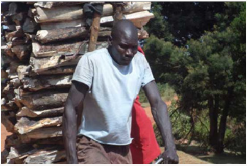
Plate 2: a). Lake Kamnyarok as it dries and water d windles b, Sondu-Miriu hydroelectric power plant in Nyakach, Kisumu
County, on February 14, 2018 and currently operating at half capacity due to the declining water levels.
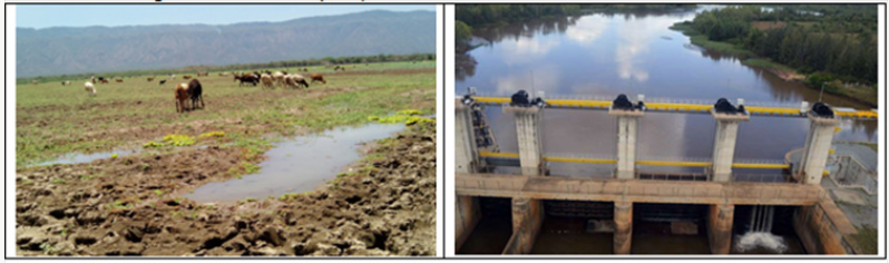
Plate 3: A section of River Nzoia where water levels have
reduced due to prolonged dry season [Duncan Ocholla,
Standard, February 2018].

The donors funding the restoration of the lake demanded that
the residents to vacate the place while the residents demanded
compensation before giving up though there are indications that
the land is an officially declared National Reserve. Though earlier
attempts to conserve the lake failed, the KWS director has been
hoping that the residents of the Barwessa Division will follow the
example of the residents of the Rimoi Game Reserve where land
reverted to the government and conservation effected as the county
council of Baringo aimed to save the reserve from extinction. For
L. Baringo, the situation has been aggravated by poor land use
resulting in siltation and output from fishing and forestry sectors in
particular has declined substantially due to resource degradation
[9]. L. Baringo is one of the important fresh water lakes in the
Kenyan Rift Valley that is primarily arid in nature and as a significant
world Ramsar site, it is important in terms of socio-economic
diversity and biodiversity. Despite this, the lake is threatened with
siltation resulting from human activities in its catchment. A study
by Lwenya [10] on Human aspects of siltation, Causes, Impacts and
Interventions to identify the factors contributing to siltation and
to suggest strategies and opportunities to mitigate the problem
indicated that the livelihoods of communities around L. Baringo
depend on livestock rearing, charcoal burning and cultivation all
precursors to degradation of the ecosystem.
Socio-economic factors, including poverty, land fragmentation;
low standard of living and earning are cited as drivers contributing
to the increased risk of watersheds [11] due to differences in land
uses and land utilization types. Land ownership influences socioeconomic
and political position and benefits of different groups of people. Land issues and conflicts that occur are related to
poverty, inequality and land reformation processes. Contestations
over land are most noticeable among the poor folks, who lack
alternative means of supporting their livelihoods [12], leading to
lack of resources conservation. Transition from forest to another
agricultural use leads to significant impact on topsoil resistance
and resilience [13]. For most wetlands, soil erosion by water is the
most common process causing sedimentation downslope and on
riverine valleys meaning there is a distinct linkage between erosion
and watershed conservation [14], and these are accelerated by
deforestation, overgrazing, and the cultivation of unsuitable or
fragile land (plate 4) [15].
Plate 4: Mau Forest Complex, one of Kenya's most important water catchments, is severely threatened by unsustainable
exploitation such as forest clearing for charcoal production.

L. Ol'Bolossat watershed has been affected by anthropic
disturbances [16]. In the headwater catchments of the central
Kenya, a prevalent cause of land degradation is unplanned
deforestation to allow for human settlements and subsistence
agriculture. In the highlands of Nyandarua, the ubiquitous landuse
changes are believed to be the major cause of the dwindling
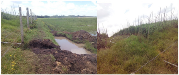
volumes of L. Ol'Bolossat (Plates 5-7), which has recently been
declared an endangered water body by the regional government
of Kenya [17]. So far, few studies have been carried out on the
spatial-temporal lands cover changes possibly affecting the size
of L. Ol'Bolossat hence lack of reliable in-situ data. Accumulation
of organic matter and silt from the surrounding farmlands have
contributed to water pollution and fluctuation of water level from
zero to 250cm depending on rainfall, surface run off and seepage
from the basin [18]. The lake suffers domestic and agricultural
pollution due to unsustainable farming practices that lead to
occurrence of waterborne diseases [19]. According to the forest Act
2005, Kenya Forestry Services (KFS) has the mandate of managing
Kenyan Forests. The law allows for collaboration and participation
of the local community living adjacent to the forest to conserve the
forest in question and in return earn a living through extraction of
non-wood products.
Plate 5: Quarrying near the lake Ol'Bolossat: Photograph taken11th February 2016.
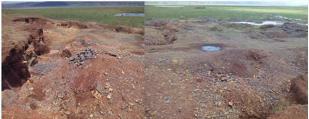
Plate 6: Effects of erosion into the lake Ol'Bolossat: 11th February 2016.
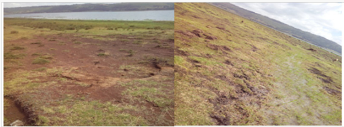
Plate 7: Water abstraction from the lake Ol'Bolossat for agriculture: 11th February 2016.
The use of agrochemicals in neighbouring farms has led to
bioaccumulation in fish and pose health risk to human as well as
fish death and causes extinction of some species [19]. In 1992 the
Fisheries department established that turbidity of L. Ol'Bolossat
was not suitable for fresh water fish though mud fish could do well
in those conditions. Nielsen [20] indicated that habitat loss and
degradation ruin the fisheries through water abstraction, removal
of vegetation for development and agriculture. Communally owned
resources experience challenges when being shared; such as unequal
sharing of resources, dissimilar priorities, location of the resource,
dissimilar cultures and unequal representation in the management
[21]. These challenges are in turn manifested in poor conservation
measures of L. Ol'Bolossat due to the tragedy of the commons. The
free rider rationale where no individual community member bears
responsibility. Poor land-use systems together with resource user
conflicts, political marginalization, poverty, weak institutions and
policies have been observed as factors contributing to land and
water degradation. Negative impacts of siltation as identified above
included destruction of fish breeding areas, flooding, poor water
quality affecting human and animal use and increased resource user
conflicts. Strategies that various institutions are undertaking such
as replanting indigenous vegetation, are show little progress due to
poor or lack of co-ordination, the nature of the landscape, lack of
funding and political goodwill. Lwenya [10] identified opportunities
for soil management systems such as use of indigenous trees and
grasses to enhance livelihoods for local communities, while at the
same time conserving the soils. Which in most cases are ignored by
the local communities as was observed by Koech [22,23] in Bura
irrigation Scheme and it surrounding areas.
A case in point is the now Controversial Mau water tower where
the forests are diminishing very fast [19]. The Mau Forests Complex
(MFC) forms the largest closed-canopy forest ecosystem in Kenya,
the largest indigenous montane forest (417,000 hectares) in East
Africa, and is the most important water catchment in the Kenyan
Rift Valley and Western Kenya. Investigations show MFC has been
affected by widespread unplanned settlements, irregular forest
land allocation and illegal extraction of forest resources destroying
approximately a quarter of the MFC over the last 15 years [24].
In addition, sections of the MFC have been impacted by forest
plantations (10% of Mau forest), subsistence and cash crop farming
and unregulated logging concessions. Scientists predict that further
destruction of the MFC will cause an environmental disaster in
Kenya and significantly reduce river flows and lake levels. This
has already been observed in the dwindling river Mara, Gucha
and others feeding Victoria basin. The MFC forests provide critical
environmental services to the country: freshwater provisioning,
river flow regulation, flood mitigation, recharge of ground water
reservoirs, erosion control, water purification, biodiversity
conservation and micro-climate regulation. The ecosystem services
support a range of economic sectors including agriculture and
tourism and the market value of such goods and services generated
annually in tea and tourism sectors alone, in excess of US$ 229
million [24]. The restoration of the MFC is of major interest to
the government of Kenya and is now a national priority. The
politicization of the removal of encroachers from several forest
blocks in the southern MFC demonstrated the importance of the
ecosystem and the extent of the vested interests involved [23].
The role of trees in agricultural production and water
catchment has become starkly apparent in Kenya following the
now well-known encroachment and degradation of the Mau
forests complex. The complex is one of Kenya's five water towers,
the others being Mt. Kenya, Aberdare ranges, the Cherangani Hills
and Mt. Elgon (
http://www.agriculturesnetwork.org/magazines/
east-africa/62-trees-farming/mau-forest-degradation &
http://
www.agriculturesnetwork.org/magazines/east-africa/62-treesfarming/
mauforest-degradation#sthash.jcM9RLhc.dpuf). It is
also argued that forest complex biodiversity and habitats provide
vital ecological services to the country, in terms of water storage;
river flow regulation; flood mitigation; recharge of groundwater;
reduced soil erosion and siltation; water purification; conservation
of biodiversity; and; micro-climate regulation. Through these
ecological services, the forests complex supports key economic
sectors in Rift Valley and western Kenya, including energy, tourism,
agriculture, and industries. The negative impact of the degradation
of the Mau forest has been felt most by farmers along the valleys
through which rivers originating from the forest drain as well as
the tea and tourism industries in the neighbourhood. Production of
tea is only possible in the vicinity of tropical forests, a crop which
is among the highest earner of foreign exchange in Kenya, requires
a cool climate which can only exist in the proximity of established
forests such as the Mau complex. The Mara and Ewaso-Ng'iro rivers
which feed the Masaai Mara Game reserve and L. Natron (flamingos
breeding site), respectively, originate from the Maha.
Restoration of degraded soil calls for the application of certain
management and conservation measures and the undertaking of
much needed precautions. Measures such as contour cultivation,
tied ridging, terracing, strip cropping, dense vegetation and
planting of cover crops, mulches, fast growing trees, selection
of proper crop rotation, quick growing species and integrated
cropping system, provision of alternative fuel sources, check
structures, protected watersheds, proper land preparation and
ploughing, application of fertilizer, amendments and organic
manures and drainage systems are quite often mentioned as the
techniques which help to protect and improve the land [25]. Soil
and water conservation programs have gained recognition in the
world as a means of water management. In the 1970 and 80's, much
emphasis in Kenya was on soil erosion control by structures such
as gabions to convey and direct runoff away from agricultural land.
Soil and water conservation, however, is now embraced as a tool
for the management of soil and water land resources in order to
satisfy the needs of the land users through sustained agricultural
production [26].
About 80% of Kenya's land mass is ASAL and supports 35%
human and 50% livestock populations [26]. The masses are poor
and depend on relief food supply for survival. To improve production
systems, the ministry of Agriculture through National Soil and Water
Conservation Program (NSWCP) in Soil and Water Conservation
Branch [27,28] initiated the soil and water management activities.
These entailed water conservation, water harvesting and water
management. These activities increases the amount of water stored
in the profile by use of bench terraces, tied ridges, fallow, contour
fallows, mulching, rotations, mixed cropping and conservation
tillage techniques as well as soil fertility improvement practices.
Water harvesting, the collection and concentration of runoff
was for the production of crops, trees, fodder and pasture
establishment [28] and also for domestic and livestock purposes.
The term harvesting is used instead of water conservation or water
management. Water management is the efficient or economic
management of available water in agriculture, and use of subsurface
and surface resources in agricultural production. In broad terms, it
encompasses conservation, harvesting, control, regulation and use
of water in agriculture.
In Kenya, the severity of soil erosion was realized as early
as the 1920s. In an attempt to arrest the situation, compulsory
terracing schemes were introduced in the 1940s, but they were
unpopular because the benefits were unclear to the local people.
Some techniques developed during this period were and are
effective but the fact that they were based on enforced communal
work meant that soil conservation was bitterly resented by the
local people [29,30]. Many terraces fell into disrepair around the
time of independence (1961) and indeed the programs catalyzed
resistance and armed struggle against the colonial regime [31,32].
By 1961, the relative proportions that were terraced in Kangundo-
Matungulu-Mbiuni in Agro-ecological zone 3 (high potential land)
and Masii in zone 4 (semi-arid upland) were essentially the same as
those of 1948. After independence however, terracing was renewed
voluntarily and farmers began to construct them within a few years
of opening new land, even in the newly settled areas of Makueni
(drier, warmer and lower zone 4 and 5 settled after 1945), where
average slopes were less steep. Un-terraced arable land had been
virtually eliminated in all three areas by 1978 where significant
progress was made between 1961 and 1978, when arable area
was itself growing rapidly due to increased population. Terrace
construction continued in the 1980s, and was promoted by the
Machakos Integrated Development Program and by 1980, erosion
on arable land was considered to be under control. The problem
was, however, only beginning to be solved on grazing land.
Little conservation happened immediately after independence
in 1963, until a new soil and water conservation campaign began
in the 1970s. This campaign started up just at the time when
people were becoming increasingly concerned about the future of
their farmlands. People were now anxious to listen to advice, and
were ready to participate in conservation activities, where slopes
were steep and erosion rate high due to unstable soil structure.
Erosion was worsening due to the expanding cropped area while
draught spells regularly affected yields, especially maize. Enforced
conservation did not work in colonial times but in the 1970s people
were ready to respond to new campaign as they envisaged accrued
benefits to their efforts. This implied that awareness and communal
participation in decision making bore fruits that were lacking in
pre-colonial times,Machakos has the reputation for being the district with the best
soil and water conservation in Kenya [29]. The national conservation
project was initiated in1974 under Swedish International
Development Agency (SIDA) sponsorship where field work in
Machakos district commenced in1979 and was later expanded
to the whole country in 1989. At community level, farmer-based
soil management practices and mechanical measures have been
practiced ever since and have been largely successful, particularly
in semi-arid Eastern Kenya, and included Strip cropping, contour
farming, ridging, mulching & rotation and physical techniques
such as terracing, cutoff drains among others. The main soil and
water conservation measures practiced here are grouped into
agronomic, soil management and mechanical. Agronomic include
increasing soil surface cover, intercropping, contour farming, cover
cropping and agro-forestry, increasing soil surface roughness, and
increasing both surface depression storage and infiltration. Soil
management measures include application of fertilizers, manures,
sub-soiling to break the hardpan, buffer strip, crop rotation and
drainage while mechanical measures include contouring, ridging
and terraces [25]. Field experiments in semi-arid regions of Kenya
have shown that soil water conservation techniques can result in
increased maize grain yields. The degree of benefit in a particular
season is dependent on rainfall amount and distribution [33]. In
Meru Central district conservation measures have been undertaken
but at a lower scale compared to Machakos District. Agricultural
productivity is very high in this humid mountainous area where
most farms are for commercial production of wheat, barley, flowers
and Asian vegetables. Small scale farmers grow tea as a cash crop.
The NSWCP lasted from 1974 to 2000 [34]. In the last 10 years
of the program, a catchment approach was emphasized where
efforts and resources were concentrated in a catchment for 1 year.
Problems and opportunities were identified within the land years
in a participatory manner, and subsequent development activities
planned. A baseline study found that both human activities and
changing environmental conditions contributed to environmental
degradation in Meru District. Concerted project interventions were
undertaken to protect and sustain the mountain environment in Mt
Kenya region. Physical or mechanical soil conservation structures
used in this area are permanent features made of earth, stones or
masonry. They are designed to protect the soil in the hilly area from
uncontrolled runoff or erosion, and retain water where needed.
They supplement agronomic or vegetative measures but do not
substitute for them. The appropriate type of physical structure to
use depends on i) climate and the need to retain or discharge runoff
water; ii) farm size; iii) soil characteristic such as texture, depth
and drainage patterns; v) availability of an outlet or waterway to
discharge excess water; v) availability of labor and, vi) adequacy of
existing agronomic or vegetative measures.
Types of Conservation Measures in Kenya
Soil and land management practices such as tillage and
cropping practices, directly affect the overall soil erosion problem
and solutions on a farm. When crop rotations or changing tillage
practices cannot effectively control erosion on a field, a combination
of measures might be considered necessary. For example, contour
ploughing, strip cropping, or terracing may be considered. The
most practiced measures in Kenya and elsewhere involves:- (i)
Agronomic such as plant/soil cover, conservation farming methods,
contour farming (ii) Vegetative: such as planting barriers (vegetative
strips), live fences, windbreaks (iii) Structural: such as Fanya Juu,
terraces, banks, bunds, cut off drains, barriers and lastly (iv) Overall
management: such as area closures, selective clearing. For more
examples and description of the conservation measures refer to
sections below depending on Soils and Agro-climatic zonation:
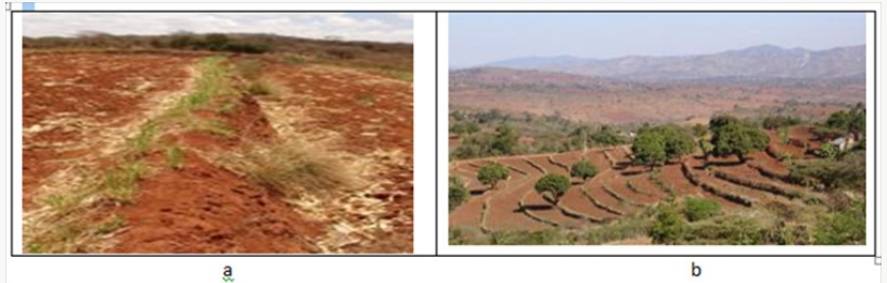
Plate 8: a). Fanya juu bund in maize field after harvest. Note Napier grass strip on upper part of bund, and maize trash in ditch
below. b). Fanya juu terraces in a semi-arid area which have developed over time into benches. Note the well-established grass
strips along the bunds @Hanspeter Liniger, WOCAT.
Terraces
Leveled bench terraces and earth banding on existing slopes
are common earth structure in Kenya. Sometimes, and especially
in the highlands, steps are constructed across hillsides and strips of
crop residues are covered with soils dug from above. The resulting
incorporation of organic matter increases soil fertility and enhances
infiltration [35] through macro porosity as well as increased water
retention in soils [36,37]. The fanya juu earth bunding system is
now modern tradition in Kenya [38]. The fanya-juu terrace (Plate
8) is designed to trap run-off and suspend sediment. A trench
is dug and soil thrown upslope to form an embankment which
is very effective in trapping runoff and there is evidence crop
performance is increased [33]. The challenge however, is the high
labor requirement in their construction and maintenance [39].
Though fanya-juu terracing is laborious, it is well understood by
the people of Eastern Kenya, and has shown to be effective. Mwangi
[40] observed highest maize yields in terraced compared to all
other conservation measures in sloping land. Machakos district
has achieved an average 1,000 km of new fanya-juu terraces
constructed each year, as well as several hundred kilometers of
cut-off drains since the mid-1980s. The conservation campaign has
been so effective that it is estimated that 70% of all cultivated land
has now been terraced as the farmers, many of whom are women,
have recognized the benefits of terracing. Conservation of moisture
and also soil has led to better and more reliable crop yields. The
remaining are mainly in the lower, drier areas where more attention
and campaign should be focused now. A fanya chini is like a fanya
juu, except that the soil is put on the lower side of the contour
trench, not on the upslope side as in a fanya juu. Fanya chini are
used to conserve soil and divert water. The resulting embankment
can be used to grow fodder. Fanya chini are easier to make than
fanya juu, but they do not lead the formation of a bench terrace over
time. They can be used on slopes up to 35%.
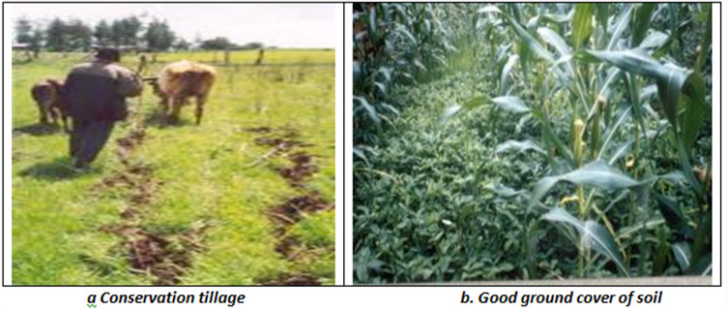
Plate 9: a). ©Will Critchley, Amsterdam, the Netherlands and b). ©Ceris Jones, London, UK (Reproduced from WOCAT,
www.wocat.net).
Conservation Agriculture in Kenya
There are three major principles on conservation agriculture
practised in Kenya: minimal soil disturbance, permanent soil
cover and crop rotations (Plate 9a & 9b). Soils under conservation
agriculture tend to considerably improve their soil organic matter
(SOM) content after applying the technology for several years. SOM
can be considered as the most important soil fertility and quality
factor influencing other soil properties such as macro porosity,
infiltration, water holding capacity or soil structure. In conservation
agriculture, only minimal or no soil tillage is applied and involves
crop seeding without mechanical seedbed preparation and minimal
or no soil disturbance since the harvest of the previous crop [25].
A number of farms are practising minimal tillage through precision
farming such as Acacia farm in Athi River and Mr Sessions' farm in
Naro Moro. The process involves use of Global Positioning (GPS)
to minimize on soil compaction to an efficiency of 99% where
deviation from ruts for truck and tractor wheels is less than 1
degree. The farm traffic uses same axle size and moves on same
position season by season during farm operations to minimize
compacting the whole land area. The crop residues after harvest
are all returned to the farm where they decompose and add to the
organic carbon pool. This has the added advantage of holding more
moisture after rains especially in these ASALs and improving soil
friability and resilience. Yields have been observed to increase
tremendously in these low rainfall areas and a promise to food
security in the region.
Cover crops for soil fertility and erosion control
Cover crops is any annual, biennial or perennial plant grown
as a mono- or poly-culture to improve any number of conditions
associated with sustainable agriculture [41]. Cover crops are
fundamental sustainable tools used to manage soil quality [42,43],
water, weeds, pests, diseases and diversity in an ecosystem.
Keeping the soil covered is a fundamental principle of conservation
agriculture. Crop residues are left on the soil surface to protect
soil surface after harvesting or during kill-down when the
cover crops are slashed and left in the field at flowering [36,37].
Additional cover crops may be needed if the gap is too long between
harvesting one crop and establishing the next. Cover crops improve
the stability of the conservation agriculture system, not only on
the improvement of soil properties but also for their capacity to
promote an increased biodiversity in the agro-ecosystem [44,45].
Cover crops are beneficial in stabilization of soil moisture and
temperature, protect the soil during fallow periods, mobilize and
recycle nutrients, improve the soil structure and break compacted
layers and hard pans [42,43], permit a rotation in a monoculture,
control weeds and pests and produce additional soil organic that
improve soil structure. Cowpea (Vigna unguiculata) for example
is an important grain legume in the tropics and subtropics and
is an ideal cover crop due to its drought tolerance, grow even in
very poor soils with very little water and fix di-nitrogen from the
atmosphere. It yields eatable grains and can be used as an animal
fodder rich in protein.
Agro-ecosystems are ecological systems managed by humans
across a range of intensities to produce food, feed and fiber. To a large
extent, humans shape ecological structures and functions of natural
processes that occur in agro-ecosystems. As agro-ecosystems
often interact with natural ecosystems in agricultural landscapes,
cover crops that improve sustainability of the agro-ecosystem
attributes may also indirectly improve qualities of neighboring
natural ecosystems. Farmers in Kenya and in fact the world over
choose to grow specific cover crop types and to manage them in a
specific way based on their own unique needs and goals. The latter
are influenced by biological, environmental, social, cultural and
economic factors of the food system which farmers operate [46].
In Kenya and parts of south eastern Africa, where smallholders
grow velvet bean (Mucuna pruriens), hairy vetch (Vicia villosa) and
sunhemp (Crotalaria juncea) as cover crops. Velvet bean have long
and short cycle varieties, are excellent ground cover and dies off
during dry season. The short cycle variety produce edible white
seeds and in some communities, leaves are used for tea. Hairy vetch
is a high altitude forage crop, whereas sunhemp is a forage plant of
the sub-humid and semi-arid regions and is more a shrub than a
cover crop. Cover crops use water during their cycle in the farm and
thus affect water relationship of the next crop [47,48].
Effects are positive when cover crops are managed to improve
infiltration and reduce evaporation [37], or remove water from
waterlogged soil to allow timely establishment of the next crop.
The effect could be negative when cover crops limit water for the
next crop or aggravate a wet soil condition [47]. Cover crops have
an influence on physical soil properties such as water relationships,
aggregation, infiltration capacity, bulk density, soil temperature
and hydraulic conductivity. Cover crops influence soil water
content through reduced surface evaporation due to mulch effect
and increased infiltration and retention of precipitation [37,49].
Judicious use of cover crops residues, either incorporated in the
soil or placed on soil surface can help in maintaining adequate
infiltration rates [50], preventing soil surface crusting [51],
improving soil aggregation [52,53], modifying the transport and
retention of water [37], heat [54-56] and aeration in soil [57].
Mannering and Mayer [58] found that final infiltration rates into
a typic Argindoll were increased from 2.3 to 5.3cmhr-1 when
2.2Mgha-1 of wheat straw was mulched on the surface. Greenland
[59] reported that runoff from tropical Nigerian soil (Paleustaff)
was five times greater where crop residues were ploughed under
than for no-tillage system with crop residues remaining on the
soil surface. Scapel [60], modeling crop residue mulching effects
on water use and production of maize under semi-arid and humid
tropical conditions, observed that even small amounts of surface
residue are effective at reducing water loss and increasing yield.
Some cover crops have been shown to suppress weeds, reduce
nematode loads, improve soil fertility, reduce water leaching
and control erosion. Kamidi [61], in a study at Matunda farm in
Kenya, observed velvet bean produced more biomass than other
cover crop species. Velvet bean relay crop was also shown to
improve the performance of subsequent crop by over 40% and
farmers preferred it more as it increased maize yield when used
together with half recommended rate of DAP inorganic fertilizer
(30kgP2O5 ha-1+30kgNha-1). Land productivity in Central Kenya
is constrained by low productivity due to continuous cultivation
without replenishment [62] hence the need to incorporate
cover crops [37]. Cover crops or green manure are grown and
incorporated (by tillage) into the soil before reaching full maturity,
and are intended to improve soil moisture, soil fertility and quality.
Studies carried out in the central highlands and in western areas
of Kenya have shown sunhemp (Crotalaria ochroleuca); velvet bean
(Mucuna pruriens) and purple vetch (Vicia benghalensis) enhance
moisture retention in the soil [63]. Sunhemp cover crop was found
to accumulate 7.2Mgha-1 DM and 111kgNha-1, though continuous
cultivation resulted in buildup of soil-borne diseases [61]. Some
cover crops exhibit allelopathy and can suppress growth of other
crops as observed in field experiments in central Kenya. Velvet bean
roots incorporated into the soil reduced tomato yields among cover
crop residue combinations, a fact attributed to the allellopathetic
nature of velvet bean roots [36,37]. Hairy vetch has been shown
to suppress initial growth and development of water melon.
Cropping systems should be designed in such a way that the soil is
almost permanently covered with plant canopy to conserve water
by curtailing excess evaporation and soil loss by wind and water
erosion. In arable crops, careful timing of sowing and planting can
help to avoid uncovered soil being washed away during the rainy
season. After the main crop is harvested, a green manure cover crop
may be sown to cover the ground and on the slopes, crops should be
grown in contour lines across the slopes (along the contour lines)
rather than vertically. This can contribute enormously to reduce
the speed of surface water/runoff thus avoid denudation [43] as
well as sedimentation of water bodies' downslope and other offsite
damages.
Green manure
Green manure are plants grown to accumulate nutrients for
the main crop where they penetrate the soils with their roots,
deliver nutrients and support infiltration of water into the soil. The
contribution of organic matter to the soil by green manure crop is
comparable to the addition of 23 to 33Mgha-1 of farm yard manure
[64]. Leguminous plants fix nitrogen (N) from the air into the soil
and this N enriches the soil and feeds plants in the area. The portion
of green manure-N available to a crop planted later is usually
about 40 to 60% of total amount of N contained in the legume. For
example, a purple vetch crop that accumulated 225kgNha-1 prior
to ploughing into the soil contributes approximately 113kgNha-1
to the succeeding grain or vegetable crop [64]. Lower amounts
are available for the second or third crop following a legume, but
increased yields are apparent for 2-3 growing seasons. When they
have built up maximum biomass, they should be worked into the
surface soil. And because they are usually cut before flowering, growing a green manure is thus different from growing a legume
crop in rotation. Once worked into the soil, the fresh plant material
rapidly releases nutrient and become fully decomposed within
a short period of time [37,48]. Aged or coarse material such as
straw and twigs decompose at a slower rate than fine material
and therefore contribute to the buildup of SOM content [64]. An
alternative to sowing a green manure crop in the field is to collect
fresh plant material from elsewhere and work it into the soil
(biomass transfer) as done by Rutunga [65] in Western Kenya.
He observed that trees and /or shrubs growing alongside crops
in agro-forestry systems could provide large quantities of green
material which can be used as green manure. Tithonia diversifolia
for example, accumulates high concentration of nutrients in its leafy
biomass, which then mineralizes very rapidly when incorporated
in the soil. Green leaf biomass of Tithonia diversifolia harvested in
Western Kenya is high in nutrients, in order of 3.5-4.0% N; 0.35-
0.38%P; 3.5-4.1%K; 0.59%Ca and 0.27%Mg on dry matter basis
[65].
Agro-Forestry in Kenya
Agroforestry describes land use systems where trees are grown
in association with agricultural crops pastures or livestock-and
there are usually both ecological and economic interactions between
components of the system. Farmers have practised agroforestry
for years. Agro-forestry as a land use system in which trees and
shrubs are grown in association with crops in the same land unit,
has the potential to arrest land degradation and rural poverty
of dry lands through service and production functions. Various
agroforestry technologies have had enormous application in Kenya
and have lifted many out of poverty as well as mitigating declining
agricultural productivity and natural resources. Notable examples
are: a) fertilizer trees such as Calliandra spp, Leucena Leucocephala,
Terminalia brownii among others that when combined with
inorganic fertilizers double or triple crop yields in degraded
lands; b) fodder trees that are used in smallholder zero-grazing
systems in ways that supplement or substitute commercial feeds;
c) improved varieties of temperate and tropical fruits that are used
to supplement household incomes and nutrition; d) medicinal trees
that are utilized on farm and conserved in-situ; and e) fast growing
timber and fuel trees that can be grown in various niches within
the farm and in commercial woodlots and plantations [66]. While
thousands of smallholder farmers are using these technologies in
the eastern province of Kenya, millions of others that need them are
yet to be reached. To achieve this goal, the key challenges that must
be addressed include supply of quality germplasm, responsive
extension services especially at county level, and legislation on
policies that provide adequate incentives for investments in
planting trees and natural resource management, and access to
markets through improved infrastructures. In many areas, most of
the fruits produced end up rotting in the field due to these setbacks.
Recently Makueni County have seen tremendous improvement in
the same after setting a processing fruit factory that is benefiting
many farmers in the area (https://www.makueni.go.ke/makuenifruit-
processing-plant-opened). These are institutional innovations
for better managing the complex nexus between poverty, food
security, and natural resource management in the dry lands such
as in Kenya [66].
Traditional agroforestry systems take the form of trees
scattered on crop fields, woodlots, homestead tree planting and
multi-storey home gardens [67]. This system requires pruning trees
of branches and tops to reduce shading. The service functions of
trees are numerous and include improving soil fertility, conserving
soil moisture and improving micro-climate resulting in increased
crop yields. Many of these trees are multipurpose, providing
a range of benefits with proven impacts that includes poverty
reduction through agroforestry products for home consumption
and sale; food security through restoration of farm soil fertility for
food crops and production of fruits, nuts and edible oils; through
negotiation support, ensuring, a fairer deal for women farmers
and other less-advantaged rural residents whose rights to land
are insecure; reducing deforestation and pressure on woodlands
by providing fuelwood grown on farms; Increasing diversity of
on-farm tree crops and tree cover to buffer farmers against the
effects of global climate change; Improving nutrition to lessen the
impacts of hunger and chronic illness associated with HIV/AIDS
and augmenting accessibility to medicinal trees, the main source of
medication for more than 80% of Africa's population. Experiments
conducted in Ethiopia have shown that wheat and maize yields
increased by over 50% under Faidherbia albida canopy (within
1.4 m radius) compared to those further away from the base of the
tree [68,69]. Similar success story have been observed in Kenya
through agro forestry. (http://www.worldagroforestry.org/news/
reaping-rewards-agroforestry-kenya). Planting trees and shrubs
on earth structures such as soil and stone bunds, terraces and
raisers combines soil conservation with production of various
products such as fodder, fruits and fuel wood. This has made the
land to be utilized more productively as trees use the area along the
structures where crops cannot be grown. The challenge to guard
against is some of the species introduced for soil conservation
becoming invasive weeds such as Prosopis juliflora which was a
very good fodder initially but has now become ecological disaster
in the ASALs of northern Kenya [70].
Hedges
Hedges are used to conserve soils in Kenya on a contour. A
contour hedge is a horizontal strip of multipurpose trees or shrubs
that is used to control soil erosion on sloping lands. These hedges
provide high quality fodder (e.g. Lucerne hedges), firewood, stakes
for climbing beans and mulch material to conserve soil moisture in
the field. Contour hedges control erosion by providing a physical
barrier as well as through increased water infiltration as a result
of leaf litter layer creating good soil structure. Over the long-term,
these hedges have resulted in the formation of terraces on the
upper side of each hedge [66], an added advantage in soil and water
conservation measures.
Improved fallows
Improved fallows have been used in some areas, where land is
left to rest (fallow) from cultivation and is enriched with leguminous
trees to speed up soil fertility replenishment. Common leguminous
trees and shrubs such as Sesbania sesban, Tephrosia vogelii,
Gliricidia sepium, Crotalaria grahamiana and Cajanas cajan were
used to rapidly replenish soil fertility in one or at most two growing
seasons [66]. A maximum of 3 years have been cited as necessary
to replenish fertility in extremely degraded soils through improved
or planted fallows [71]. The trees and shrubs are interplanted with
crops such as maize during the rainy season and are left to grow
during the dry season tapping soil water with their deep taproots.
Right before the next rainy season, farmers harvest the fallows,
remove fuel wood and incorporate biomass (leaves, soft stems and
leaf litter) into soil prior to planting maize in Eastern Kenya. In
western Kenya, maize yield following improved fallows averaged
4.1Mgha-1 which is much higher than those from non-fertilized
plots continuously planted with maize at 1.7Mgha-1 [72,73]. Fallows
improve soil structure, ease tillage and facilitate conservation
tillage [73]. Fallows increase soil's water infiltration capacity and
are capable of deep root development >7m. Fallows also reduce
soil erosion, by maintaining a leafy canopy during dry seasons
and more vigorous crop growth during rainy seasons. Better soil
conservation results have achieved when fallows were combined
with contour hedges planted to fodder species [70]. It can therefore
be argued that productivity on degraded lands can be restored
and food security effectively achieved with conservation practices
country wide. In a survey in western Kenya, over 16,000 farmers
were using improved fallow in 2000 [70]. The only challenge now
is the increased population which has made it almost practically
impossible to leave land fallow for more than a season. This in itself
does not allow land to recover and regenerate adequately to realize
the accrued benefits of fallowing. But for those in ASALs and with
large tracts of land, the benefits cannot be overemphasized.
Vegetation strips
Vegetation strips are usually narrow grass strips grown across
slopes. The grass acts as a barrier to runoff thus encouraging
deposition of sediments and eventually leading to terrace
development. The commonly planted grasses in Kenyan degraded
lands are Imperata cylindrical, Vetiveria zizanioides Austin 2017
and Pennisetum purputeum. Species such as Pennisetum purputeum
are also used as fodder to draft animals and other livestock hence
dual purpose. Live fences surrounding cultivated fields acts as
modification of vegetative strips [35]. Fodder grasses are planted
on top of the terrace bank to hold the earth together and these
benefits the farmer from a source of valuable cattle feed, and land
which might otherwise have been unproductive is put to good use.
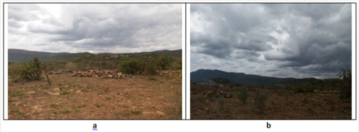
Plate 10: a). Rehabilitation of degraded rangeland in its initial stage: stone lines are established after the area has been cleared
of invasive tree species and b). Over sowing with grass seeds, manuring with cattle dung and applications of lime speeds up
regeneration of the grass cover.

Plate 11: a). Natural stones piled to the left for high pasture improvement and building a home in Kisamis, Kisamis, Kenya. b).
In the background a stone fence plus a mound of gravel from the quarrying in Kisamis, Kisamis, Kenya.
Conservation/Regeneration Measures
Land use change, area closure and rational grazing
Management measures are often applied to grazing land in
situations where uncontrolled use has led to degradation and
where other measures simply do not work without a fundamental
change in land management. Enclosures are used for protection
from grazing and thus allow regeneration of vegetation cover. Such
measures are essential for the rehabilitation of badly degraded
areas where technical measures and other interventions are often
not adequate on their own but can act in a supplementary manner
(Plates 10-12). Other measures include intensification of grazing
land use where fodder crops are planted and used for cut-and-carry
feeding of livestock. Management measures are advantageous in
that they do not involve very high capital investments or labour. It
should be noted that taking land out of use can lead to increased
pressure on neighbouring land, which may also be in poor
condition and vulnerable to further degradation. The challenge
in management measures is that they are not clear-cut, they
require great flexibility and responsiveness at initial stages and
in subsequent years that follow. There are also implications for
land tenure that can complicate decision-makings that may sour
relationships between neighbours [74] as they try to conserve their
land holdings.
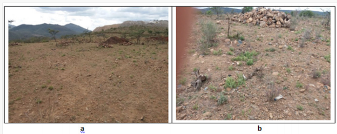
Plate 12: a). Red soil brought from Kiambu for tree. b). Natural stones piled for pasture improvement planting in Kisamis,
Kenya.
Contour farming
Contour farming involves ploughing, planting and weeding
along the contour, across the slope rather than up and down. Contour
lines are lines that run across a hillslope such that the line stays at
the same height or altitude and does not run uphill or downhill. As
contour lines travel across a hillside, they will be close together on
the steeper parts of the hill and further apart on the gentle parts of
the slope. Research show that contour farming alone can reduce soil
erosion by as much as 50% on moderate slopes. However, for slopes
steeper than 10%, other measures have been used in combination
with contour farming to enhance its effectiveness. Caution is mostly
observed to avoid incorrectly establishing contour lines as they risk
to actually increasing erosion. Contour ridges are commonly used
ASALs to harvest water, and in the humid- higher rainfall areas
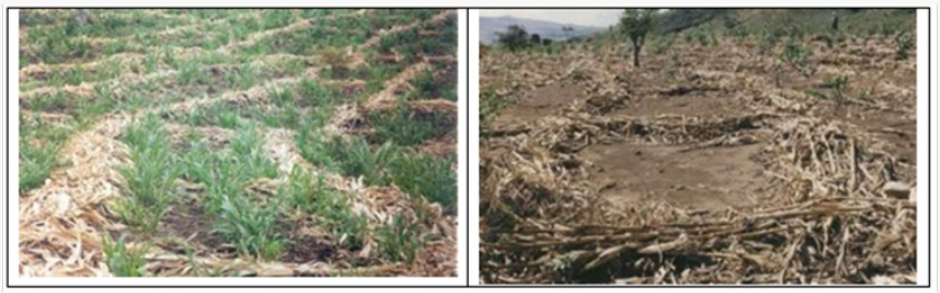
for growing potatoes. Trash lines made by laying crop residues or
"trash" (Plate 13) in lines along the contour have been shown to
slow down runoff and trap eroded soil, eventually forming terraces.
Research however, have shown that contour lines can be destroyed
by termites eating the trash thus compromising the conservation
agenda envisaged. To overcome this setback, grass barrier strips, for
example fodder grass such as Napier is planted, or the contour left
with natural grass. These are effective soil conservation measures
on soils that absorb water quickly, and on slopes as steep as 30%.
Plate 13: Trash lines @Berhanu Fentaw, Addis Ababa, Ethiopia and @H. KrÜger from WOCAT, respectively (
www.wocat.net).
Trash lines
Trash lines range from simple bunds of cereal and legume Stover
to more sophisticated pegged brush lines according to Gichuki
[75]. Apart from impeding runoff and enhancing infiltration, trash
lines also increase soil organic matter content when incorporated
into soil during ploughing, enhance soil macro porosity, water holding
capacity, soil hydraulic conductivity as well as improve soil
fertility upon decomposition and mineralization [37]. Trash lines
are extensively used in the Tharaka area of Meru [76] in Northern
Kenya. Trash lines though with no much support from government
are used as a traditional soil conservation measure since colonial
times in Kenya. Their effectiveness depends on the size of the bunds
and their spacing. Large trash lines have been shown to reduce
erosion, increase both infiltration and available water to crops
leading to increased crop yields [11,77].
Cutoff drains, retention and infiltration ditches
Cutoff drains are usually dug across a slope to intercept surface
runoff and carry it safely to an outlet such as a canal or stream
with minimal risk to aggravating erosion. They are used to protect
cultivated land, compounds and roads from uncontrolled runoff,
and to divert water from gulley heads [77]. Retention ditches are
dug along a contour to catch and retain incoming runoff and hold
it until it seeps into the ground. They are an alternative to cutoff
drains when there is no nearby waterway to discharge the runoff
into. They are used to harvest water in semi-arid areas. Infiltration
ditches are one way of harvesting water from roads or other
sources of runoff and consist of a ditch, 0.7-1.5m deep, dug along
a contour, upslope from a crop field. When it rains, runoff water is
diverted from the roadside into the ditch, which is blocked at the
end to hold the water. Water trapped in the ditch seeps into the soil
and maybe used for rain harvesting agriculture where moisture is
stored in the ground. This is has been used in the semi-arid area in
Baringo district in the Kenyan Rift Valley area for increased food
production [9].
Broadbeds and furrows
In a broadbed-and-furrow system, runoff water is usually
diverted into field furrows 30cm wide and 30cm deep. The field
furrows are blocked at the lower end to hold the water and when
one is full, the water backs up into the head furrow and flows into
the next field furrow. Between the field furrows are broad beds
about 170 cm wide, where crops are successfully grown.
SWOT Analysis on Soil Conservation in Kenya
Soil and water conservation processes in Kenya can be
summarized into strengths, weaknesses, opportunities and threats
(SWOT) where crop residues are considered herein
Strengths
Merits of soil conservation includes: Advantages of mulch
are similar to those of crop residues in that they increase water
infiltration [37,78], decrease run off [78], and have greater soil water
availability than such materials as saw dust and wood shavings. In
relation to increasing infiltration, studies in Kenya reported that
in a 12% slope of well-structured freshly cultivated soils, where
4Mgha-1 of grass mulch equivalent to 79% cover reduced runoff
from simulated rainfall to 5%. This is an indication that at 80%
cover, equivalent to 4Mg ha-1 maize straw, would be appropriate for
increasing rainwater infiltration hence its conservation in soil.
Both residues and mulches provide additional benefits, notably
less water loss by direct surface evaporation, less weed incidence,
softer and more workable soils and increased earthworm activity
[36,34,79]. After residue incorporation, there are additional
nutrients [37,80] released into the soil and subsequently increased
yields. In western Kenya, mulching with Tithonia spp has given
substantial yield increase of maize (Zea mais), Kale (Brassica
oleracea), tomatoes (Lycopersicon esculentum) and French beans
(Phaseolus coccineus). The net profit of mulching kale ranged
from USD 91 to 1,665ha-1[81]. In the semi-arid areas west and
north-west of Mount Kenya, maize yields increased by a factor of
4.4 when 3Mgha-1 of mulch was applied [82]. A substantial number
of farmers have increased crop yields using improved fallow and a
local administrator in Siaya district, Kenya, summarized the results
of the first year thus: "For the first time there have been no hunger
periods in Luero village. Only ears of maize have been reported stolen
this year (July, 1998). One farmer from Vihiga district, western
Kenya reported his annual cash income to have increased tenfold
with the sale of kale planted following improved fallows [66].
When soils are badly degraded that they must be taken out
of production, soil porosity can be restored through the action of
biological processes. This has been achieved by following for one or
several years under natural vegetation enriched with fast-growing
leguminous trees, or planted fallows. The accumulation of large
amounts of biomass on the soil surface from the fallow vegetation
associated with high biological activity and strongly developed
root systems promote the biological recuperation of soil porosity
as witnessed in Bamburi/Haller park nature trials at Mombasa,
Kenya. Here land has been reclaimed from a quarry and a tourist
park established that generates much revenue through local and
foreign exchange earnings. Biological incorporation of residues
into the surface soil resulted in higher organic matter content in
upper few millimeters of soil, which progressively extended into
deeper layers overtime. The permanent cover of surface residues
encourages soil faunal activity, which in combination with higher
soil organic matter contents leads to improved soil porosity
FAO. The work is still progressing as new quarried land is being
restored. Well adapted leguminous cover crop are currently being
adapted in many marginal lands of Kenya as they often speed up
the recuperation of soil porosity compared to a natural vegetation
fallow because larger amounts of biomass are rapidly produced by
the cover crop such as velvet bean [37]. Whereas natural vegetation
fallow may require 3-5 years, a cover crop may restore initial soil
porosity in 1 year.
Conservation measures in agro-forestry systems have
tremendously improved the supply of fuel and forest products
such mangoes in Siakogo, Embu and Makueni Counties in Eastern
Kenya(https://www.makueni.go.ke/makueni-fruit-processingplant-
opened) thus boosting farmers' incomes. It appears that
an integrated approach with appropriate macro-economic policy framework for input and output markets as well as land tenure,
provision of services such as education, health, agricultural
extension and adequate infrastructure such as transport, water and
electricity have played a major role in reversing land degradation
in Kenya (http ://siteresources.worldbank.org/ KENYAEXTN /
Resources /ERS.pdf).
Weaknesses or demerits associated with conservation
Cost of labor for collecting, transporting and applying mulch
is prohibitive to the peasant farmers (http://siteresources.
worldbank.org/KENYAEXTN/Resources/ERS.pdf). This is not
the case with cover crops residues, which are produced on-site
unless for biomass transfer Runtunga 1999. Often there are no
suitable mulching materials in the vicinity of the farms, or labor is
insufficient when required. Transporting large quantities of mulch
for large scale cropping is seldom economical as there is a cost
of slashing the cover crop though not the case for smallholders.
Similarly, lopping trees and distributing branches and leaves over
the cropping area requires considerable labor. On steep slopes, the
application of residue cover crops is not easy and these materials
are easily washed downhill. Mulching cannot be applied after
emergence of closely spaced crops as it smoothers them thus
interfering with their growth and performance. Mulching materials
and crop residues are often grazed by cattle belonging to the
farmer, the community or landowner (in case of tenant farmer), fed
to livestock, or sold as fodder hence a conflict of interest amongst
competing uses. Sometimes thee materials are in high demand for
thatch or fuel.
In ASALs, mulches are rapidly consumed by termites, and in
hot humid climates, they decompose rapidly [37]. Use of mulch
progressively decreases soil fertility (mining) with time, where
mulching materials are produced, unless manures or fertilizers
are applied. Soil erosion may also degrade the source areas where
the cover crop is provided by the vegetation is removed for use as
mulch in another location. Use of covers is more common in subhumid
and humid zones because of the greater productivity and
thus availability of vegetative materials. Nevertheless, they are
particularly suited to semiarid areas when materials are available
and in the absence of severe termite problems. Mulches are often
applied to limited areas of high-value horticultural crops and homegardens
in easily accessible fields with gentle slope. Peasant farmers
have difficulties affording them. Constraint of soil recuperation
by natural vegetation fallows in mechanized production systems
is that of eliminating trees and excavating roots before returning
them to cropping. If manual system is applied, the problem is less
serious. Herbaceous and shrubby cover crops can be eliminated
much more easily by slashing or mowing and the subsequent crop
may be sown directly into the residues of the cover crop.
A problem exists of inadequate supply of appropriate
germplasm material and a lack of transport [70] to the intended
sites on time and this normally inhibits or delays farm operations.
Crop production in semiarid areas involves a lot of risks, including
flooding and draught. This makes it difficult for farmers to realize
the full benefits of soil conservation. Irregular rainfall reduces
the effectiveness of vegetation erosion control practices. Global
concern about deforestation caused by fuelwood shortages
prompted the introduction of Prosopis juliflora to many tropical
areas in the 1970s and 1980s. P. juliflora is a hardy nitrogen-fixing
tree that is now recognised as one of the world's most invasive alien
species. The introduction and subsequent inva¬sion of P. juliflora in
the Garissa-Tana River (Plate 14) and Baringo areas of Kenya has
attracted national media attention and contra¬dictory responses
from responsible agencies. A publication by Mwangi [83] assessed
the livelihood effects, costs of control and local perceptions on P.
juliflora of rural residents in Baringo area. They noted that unlike
some other parts of the world where it had been introduced, few
of the potential benefits of P. juliflora had been captured and very
few people realised the net benefits in places where the invasion
was most ad¬vanced. Strong local support for eradication and
replacement appears to be well justified. Mwangi [83] advanced
that sustainable utilisation of Prosopis would require considerable
investment and institutional innovation. In some areas, Prosopis
juliflora used as strips have turned into weeds [70], affecting crop
performance, while in others, species such as Eichornia crassipes
(Water Hyacinth) choke water bodies such as Nairobi dam and L.
Victoria waters.
Plate 14: Prosopis juliflora invasive weed along Garissa Bura Road, Kenya.
Water and nutrient competition is also common in agroforestry
leading to low yields. Calliandra spp. has been reported in the lower
dry areas of Embu county, Kenya to compete effectively with maize
crop for moisture (Personal communication 2009). Some of these challenges involve centralized planning by experts, planning on
basis of geographical area rather than natural village units of land,
and too much emphasis on soil erosion rather than conservation of
moisture for plant productivity. These factors need to be addressed
by the Government and other stake holders to build on the current
soil conservation measures.
Opportunities
Runoff control and runoff harvesting produce significant crop
yield increases in average years. Water conservation strategies may
therefore allow for earlier planting or be accompanied by increased
planting densities, both of which may result in yield increase [84].
More land maybe brought under agriculture or pastures through
water harvesting and erosion control on steep lands. The outcomes
will be higher incomes and better nutrition to the people who are
therefore healthy and productive [9]. The environment will also be
conserved hence less pollution. Current and on-going research on
Prosopis juliflora for biofuel and animal feeds may lead to better
utilization of the noxious weed as well as fertilizer formulation
from both Prosopis juliflora and Eichornia crassipes [85].
Challenges
Conservation measures suggests that population growth and
agricultural intensification are compatible with environmental
recovery [30]. However, it would be a misinterpretation to imply
a constantly positive effect of population growth and land quality
and health. Even for places like Machakos County where positive
effect is evident, signs indicate it may be necessary to slow down
population growth in order not to exceed the optimum population
size, given the prevailing natural resources, infrastructure and
services (http://povertyenvironment.net). The proximity to
Nairobi, and therefore markets for agricultural products, has
greatly enhanced the adoption of conservation in Machakos and
subsequent economic growth. Indeed, other regions in Kenya may
not be as fortunate in terms of nearby markets. Developing the
necessary infrastructure to open up regions for trade is therefore
an important motivation strategy as farmers need incentives to
invest in costly conservation measures. It is evident that yields are
now declining in areas that have been under permanent cultivation
for the longest time since conservation measures were introduced
in the early 1940s. In such areas, efforts are required to ensure
the sustainability of agricultural production. When degraded soils
are severely compacted, deep tillage with subsoiling immediately
prior to sowing the cover crop encourages establishment and
development of cover crops. If the degraded soil is severely deficient
in phosphorus, the application of P fertilizer becomes necessary to
encourage establishment of the cover crop. Obare [86] summarises
the Underlying causes of deforestation and forest degradation and
possible solutions in Kenya as follows:
Poor Policy Formulation and Enforcement
Land polices in totality often tend to be agrarian favouring
large-scale commercial farmers. They are inconsistent as their
application varies from region to region or sector or to sector
depending on the land tenure systems leading to mis-use, confusion,
non-use and indiscriminate destruction of resources with eventual
degradation some of which might be irreversible as the soils loses
their resilience.
Political Expediency
Due to political rivalry, forests are usually given to supporters
of particular politicians as a bribe or repayment for political
patronage.
Macro-economics
Cash crop production for export: Intensification of cash
crop farming is on the increase on cleared forest land with major
examples being flowers, horticulture, tea and coffee. These cash
crops are grown for export to industrialized nations and compete in
the world market for the much needed foreign exchange earnings.
The indigenous communities such as the Ogieks (forest dwellers)
have claimed in the past that pyrethrum and pesticides applied on
the farms kills bees and have rendered bee keeping unviable hence
not a suitable alternative for harvesting of honey in the forest.
Liberalisation: The liberalisation process has put a lot of
emphasis on the privatisation of public land and forests resulting in
the non-recognition of customary resource tenure. The Ogieks have
been denied their ancestral rights to the forest land they occupy.
Structural adjustment programmes: As a result of the
restructuring process in government involving such measures as
retrenchment in public sector and reduction of budget allocations
to various ministries and departments, ministries such as that of
environment and forestry department are not spared. Most of the
personnel such as forest guards are declared redundant making it
difficult to manage the forests efficiently thus encouraging illegal
use of the resource. Currently there is demotivation due to poor
police officers' pay [87] with some threatening mass resignation
thus affecting forest destruction through logging activities that is
decimating our tree cover.
Population pressure: Most of the Kenyan people are
concentrated in the agricultural land, about 20% of the country's
area. This means a lot of strain being exerted on forest land which is
seen as free land for potential use. A lot of excision has taken place
in forests such as Ngong, Mau and Hombe in Mt Kenya just to name
a few. In Mau forest, those neighbouring the forest would like to
reap benefits from it and some pressures their politicians for such
land regardless of the loss in the ecosystems functions.
Actors
Those responsible for the underlying causes at different levels
include:
Local level
Farmers growing cash crops who continue to increase the area
under cultivation to get more income. The county governments continue allocating land to these farmers without considering
conservation versus degradation issues.
National level
The policy makers do not have the good will to incorporate the
lifestyle of the indigenous communities such as the Ogieks, Masaai
and Ndorobos in their national plans. The governments, both
at national and county level should train their staff to recognise
the role of indigenous knowledge in forest conservation to curb
further degradation. Political leaders keen on distributing land to
gain mileage without considering long term effects of destroying
the catchment areas should be censured or even blacklisted from
holding public office to streamline this anomaly. Some indigenous
tribes such as the Ogieks are not represented in parliament by one
of their own and attempts have been made in the past to assimilate
them into other communities leading to further marginalisation.
Global level
The industries and consumers in developed world promote
export of cash crops in bulk as raw material with no value addition.
Structural adjustment programmes advanced by World Bank that
are economically oriented with little or no regard to sustainable
environmental conservation have led to encouragement of intensive
exploitation of forest land leaving communities vulnerable to the
vagaries of nature and more so climate change, global warming
as more CO2 is released into the atmosphere due to poor carbon
sequestration. Globally averaged concentrations of CO2 reached
403.3 parts per million (ppm) in 2016, up from 400 ppm in 2015
(https://www .theguardian.com /environment /2016/ sep /28 /
the-world-passes-400ppm-arbon-dioxide-threshold-permanently)
because of a combination of human activities and a strong El Niño
event," according to The Greenhouse Gas Bulletin [88], the UN
weather agency's annual flagship report [89]. These two actors
operate behind the scene (Source 1). They influence those at local
level as they come up with the measures on how to run the global
economy. The decision made by them will determine the kind
of national plans in place and therefore influence affected local
communities.
Source 1: https//upload.wikimedia.org/Wikipedia/
commons/1/15Mauna_Loa_Dioxide.
Oversight Discussion on Soil and Water Conservation
Crops grown under soil incorporated or mulched with cover
crops have been observed to have higher yields and better water use
efficiency than those grown traditionally without any conservation
measures. [37] Working at Kabete, Kenya found yields and WUE
of tomato (Cal J) was superior than control plots where Mucuna,
Sunhemp and vetch were mulched or incorporated in a Nitisol.
Kenya is favoured by having high-altitude areas of good agricultural
potential where most of the population lives. Nevertheless, Kenya
suffers occasional food shortages. One of the reasons for this is
that over three quarters of the country is, in fact, ASALs and these
areas are home to an increasing number of people as the country's
population rises at about 4% per year; one of the fastest growth
rates in Africa. Agricultural production is also threatened in many
parts of the country by soil erosion. Soil conservation techniques
for the highland areas are well developed and the conservation
activities of self-help groups in places like Machakos County in
eastern Kenya are particularly effective unlike in most other parts
of the country. In the more arid areas, such as Turkana district in
the far north-west, water harvesting is needed for dryland cropping
to be possible. Several projects testing systems of water harvesting
as a viable water conservation technique for Kenya are currently in
available.
The lower rainfall in semi-arid areas compared with that
in humid climates does not mean a corresponding low level of
soil erosion by water in these places. Indeed rainfall erosion has
been observed to be higher in ASALs than in many other climatic
zones. This is partly because the semi-arid areas have a high
proportion of convective thunderstorm rain of high intensity and
high erosive power. There is also poor protective vegetative cover
at the beginning of the rainy season and some of the soils common
in in these areas are particularly vulnerable, either because they
have poor resistance to erosion thus high erodibility, or because
of their chemical and physical properties and low organic matter
content. For example, alfisols suffer a particularly high loss of
productivity per unit loss of soil [90]. Gully erosion as witnessed in
Kalama, Machakos County can be severe in these semi-arid climates
and the benefit/cost of gully control needs to be considered when
conserving these lands. Successful but expensive gully conservation
like the Australian one for example might not be suitable for third
world countries like ours with budgetary constraints [91].
There are always strong links between measures for soil
conservation and measures for water conservation, and this applies
equally in semi-arid areas. Many measures are directed primarily
to one or the other, but most contain an element of both. Reduction
of surface run-off by structures or by changes in land management
help in reducing erosion. Similarly, reducing erosion usually involve
preventing splash erosion, or formation of crusts, or breakdown
of soil structure, all of which increase infiltration, and so help the
water conservation. In arid and semi-arid areas, rain falls only
during a few months in a year, but is unreliable even during those
few months. It typically comes in a few, heavy storms, and much of
the water runs off the surface, causing flooding and erosion. Water
conservation relies on trapping as much of this water as possible
and storing it on the surface (in tanks or reservoirs) or allowing it
to sink into the soil in order to raise the water-table and increase
the soil-moisture level. Unfortunately there is no clear cut policy
or legislation towards water harvesting in Kenya even in teaching
institutions like Universities and research stations that should take
the lead unless it is for postgraduate research. Little or no funds are
allocated for such activities by the government and even for this
postgraduate research; the money is sourced through calls from
outside donors [92-99]. A lot of water that could be harvested on
hillsides, roads, rocky areas or even rooftops goes to waste only for
the inhabitants, county and national government leaders to lament
there afterwards when the rains are gone and the dry season sets
in. Even where storage pans are dug, it is at a very small scale and
cannot sustain the locals when the draught is prolonged like was
the case recently. At present rains are pounding the whole country
with roads being washed away as in Mai Mahiu, floods bringing
buildings down in Nairobi and environs [87] but not a single
water harvesting venture has been put in place either by county
or national government. More water can seep in if it is spread
over a large area of soil rather than being concentrated into
fastrunning
streams. So water-conservation efforts should focus on
stopping the water from becoming concentrated in the first place
by ensuring a protective cover of vegetation on the soil surface,
slowing down the flow of running water by directing it into pits and
dams [100-105], and spreading the water out over a large area (for
example, via contour ditches) and above all, enhance the infiltration
of water into the soil by improving the physical soil quality with
conservation tillage techniques that aid in percolation [106].
Integrated Programmes
The current approach by soil conservationists unlike in the
1980s is moving away from using mechanical works and structures
in soil conservation programmes that were paid for by a government
or donors such as increasing awareness of the ineffectiveness of
terracing programmes alone. Conservationists are now moving
towards the view that the only effective programmes which have
the full support of the local people benefit [107]. The subsistence
farmer cannot afford to respond to philosophical or emotional
appeals to care for the soil, and this means that conservation
measures must have visible short-term benefits to the farmer such
as increased yields per unit of land, or perhaps better production
per unit of labour, or perhaps improved reliability of yield. The idea
of local communities working together in groups on tasks which
require a big labour force is well-established in many countries,
particularly for planting, harvesting or building structures. The
practice can now be successfully extended to conservation works
with advantages such that the village group can tackle jobs too big
for an individual or family; generates a sense of communal care
for the land and these work groups are a good forum for extension
workers to encourage improved farming methods [108].
Conclusion and Way Forward
Possible actions to counteract the underlying causes of
land and forest degradation in Kenya
Decision Makers should be re-oriented on the need to involve
local stakeholders in policy formulation. The formulation of
an integrated and comprehensive land policy geared towards
attaining sustainable development is key and should consider
natural resources holistically not sectoral and also harmonise what
is in existence. This means restricting decision making process and
policy intervention to ensure collaborative forest management and
security of tenure to the rightful individuals, community and the
governments. Management of the forest should be done by a board
of trustees drawn from various forest stakeholders and should
be people of integrity, incorruptible and devoid of politics. A bill
should be tabled in parliament at National level, and in the county
assembly in the devolved units that empowers ministers at these
levels and ensure that decision making process is consultative right
from grassroots level.
The village council of elders should be revived for the purpose.
Disciplinary measures through harsh penalties for those destroying
forests either through illegal logging or charcoal burning should
be the norm without political interference. Elaborate measures
should be put in place to allow the public accessibility to timely and
relevant information as a means of empowering them and building
their confidence in participation. This is more so even where
the National or county Government plan massive infrastructure
developments through these fragile ecosystems such as the recent
Standard gauge railway line from the port of Mombasa to the
capital city Nairobi or the proposed LAPPSSET project from Lamu
port in the ocean to South Sudan. Advocate for sustainable forest
management such as the on-going Forest Action Network in Mau
that is creating awareness among the Ogiek community living there
on policy and legal issues. This helps in sensitising them on their
rights to the forest resources. The project has been documenting
information on the Ogiek's traditional forest management practices,
and organising workshops for different stakeholders of the Mau
forest to enable them work out a plan of action for achieving
sustainable forest management.
Advocacy at Global level to sensitise the consumers and
industries on accepting goods such as forest products, cash crops
that are sustainably produced and the World bank prevailed upon
to come up with environmental responsive polices and action
plans. Promoting conservation of forests through sustainable
harvesting of products and reforestation. A program to re-establish
forests in marginal lands should be advanced in areas such Mara to
save the ecosystem from collapse. Promote activities that reduce the
pressure off forests like sericulture, butterfly and chameleon
farming, improved bee-keeping, folder banks especially in arid
areas like Kajiado and northern Kenya and bio-intensive agriculture
and farm forestry. Precision farming is also playing a major role in
and around Athi-River in Acacia farm and in Naro-moru Sessions'
farm. Facilitate markets and value addition process to existing
product such honey, medicinal plants and other plant and animal
species with economic benefits to the communities. Build capacity
on forest users to enhance technology base on relevant fields such
as biodiversity enrichment and management regimes. Monitoring
physical and environmental changes using advanced technology
such as remote sensing and GIS with a view of counteracting the
observed changes in order to enhance potential of the forest