Lupine Publishers |Agriculture Open Access Journal
Mini Review
In developing nations like the Kurdistan region in Iraq, experience shows that, during the initial phases of development, urban expansion becomes a top priority and as a consequence agricultural land is often considered as a set aside for forthcoming urban expansion. Hence, agricultural lands are at risk due to the loss of land to urbanization. The Kurdistan region in Iraq is highly suited for agriculture as it boasts significant areas of arable land, fertile soil and various micro-climatic zones [1,2]. Potentially, agriculture in the Region could become an important public revenue and the rehabilitation of this sector translates into reviving village life, creating more job opportunities, encouraging new industries, and upgrading the standard of living and quality of life [3,4]. Agriculture in the region is characterized by its low productivity due to a number of reasons which include using outdated farming practices, not matching agricultural produce with the best fitting environmental conditions. An added factor can also be the loss of prime productive land to urbanization. This note assesses the influences of urban expansion, on wasting arable land and the ultimate consequence on sustainable agricultural production in the Kurdistan region, Iraq.
A practical way forward for increasing agricultural productivity is through land capability and suitability mapping, which spatially and temporally summarizes the extent to which the inherent physical capacity of the land and the associated favorable climatic conditions in a particular area is agricultural production without reducing the soil’s long-term productivity, subject to good management Dent and Young, 1981; Emery, 1986. Hence, land capability and suitability classification are a specific grouping of soils made primarily for agricultural purposes.
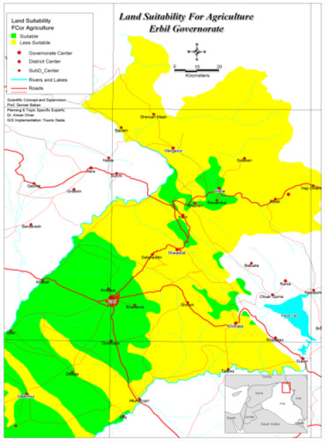
The suitability of land for plant production in Iraq was developed based on the Soil Survey Geographic Database (SSURGO) which rates soils based on their ability to support cultivation and farming of common crops without deterioration of the soil over long periods of time. It contained 8 classes ranging from the soils with the potential for agricultural production (class I) to areas not capable of agricultural production such as rock outcrops and sandy heath (class VIII). Under good management, soils in classes from I-IV are capable of producing common cultivated field crops, pasture plants, range plants, and forest trees without reducing the soils long-term capacity. Using the suitability of land for plant productions for Iraq, a new GIS based Land capacity and suitability map was produced for the Erbil governorate and provinces. This binary map was developed based on clustering the 8 classes into two classes. The first soil classes ranked from 1-4 are considered as “Suitable”, while the other classes were considered “Less Suitable” (Figure 1). The map shows that the main urban centers are located on the most suitable land for agriculture as the community is agricultural in nature.
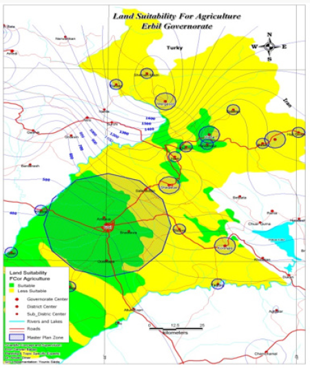
The outcome was then correlated with recently developed Master plans for Erbil governorate and provinces. Using this information, a GIS based map was produced (Figure 2). The results disclosed the estimated loss in productive agricultural land when the current Master plans are implemented, making the estimated loss in Erbil governorates to be around 1514Km². Therefore, under current practice, urban expansion can only be implemented through wasting valuable productive agricultural land. Clearly, the paradox is that as the population grows, the need for urban expansion grows, and the latter can only be carried out by wasting productive agricultural land and endangering sustainable agriculture. This suggests the need revise to the Master plan and to find a healthy balance between development and sufficient food production for the current as well as the growing population. Furthermore, the outcomes can provide the necessary information on the broad agricultural products most physically suited to an area, that is, the uses with the best match between the physical requirements of the use and the physical qualities of the land. Consequently, it can provide guidance on the inputs and planning requirements associated with different management schemes for increasing agricultural production within the region.


No comments:
Post a Comment